INCIDENT UPDATE
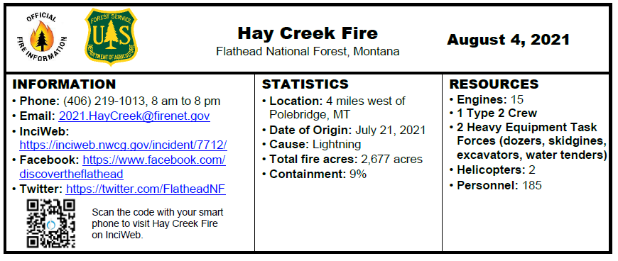
There was minimal growth to the fire on Tuesday, as fire activity was tempered by cooler temperatures and higher humidity levels. Smoke continued to be produced on both the east and west sides of the fire, and an infrared scan detected heat around the entire fire perimeter. The Incident Management Team began establishing two spike camps for approximately 100 firefighters in the Home Ranch Bottoms area to reduce travel time to the fire, reducing fatigue and increasing efficiency in operations as crews anticipate future fire fighting needs to control this “sleeping giant.”
Crews will be flown to the Coal Ridge Cabin today to evaluate needs for structure protection and the possible use of structure wrap to protect the historic structure in the event it is reached by fire. Crews are establishing temporary stream crossings to allow fire fighting vehicles to continue to move west on Hay Creek Road #376.
Both hand crews and heavy equipment continue to expand and improve primary and contingency lines in the Spruce Creek and Red Meadow areas. The structure protection group continues to work with local agencies to develop the structure protection plan.
Please exercise caution when driving in the area due to fire fighting traffic and equipment. Most of Montana is experiencing EXTREME fire danger; Stage 2 Fire Restrictions are in effect. Know Before You Go- Visit www.mtfireinfo.org for Montana fire restrictions.
EVACUATIONS
Evacuation Warnings include all residences east and west of the North Fork Road from Home Ranch Bottoms north to and including Moose Creek Road and the community of Polebridge. Glacier National Park has issued an Evacuation Warning for the North Fork area of Glacier National Park north of Logging Creek. See details at https://go.usa.gov/xFjcA and Current Fire Information – Glacier National Park.
CLOSURES
Road and trail closures are in place. See details at Inciweb: https://inciweb.nwcg.gov/incident/article/7712/62192/.
WEATHER AND AIR QUALITY
Seasonal temperatures are expected today and tomorrow with a slight chance of a shower or thunderstorm. A front moving in Friday will usher in notably stronger winds later Friday afternoon through Saturday with gusts to at least 40 mph possible. A slight chance of an afternoon shower or storm will continue through the weekend. For the most current fire weather forecast go to https://www.weather.gov/wrh/fire?wfo=mso. For smoke and air quality go to http://svc.mt.gov/deq/todaysair/. For current visibility in Glacier NP see https://www.nps.gov/glac/learn/photosmultimedia/webcams.htm.
INCIDENT BACKGROUND
The Hay Creek Fire was reported on the evening of July 21, 2021. It is burning in the North Fork area of the Flathead National Forest and is being managed under a full suppression strategy.
Public and firefighter safety is the number one priority. Additional priorities include minimizing impacts to private property, structures and critical infrastructure, and road corridors and natural resources. Due to high fire activity in our region and across the country, resources are limited and prioritized.
