Mark Heaphy has pointed out that property owners should be keeping track of hours spent sawing, stacking, burning and removing downed trees that resulted from the recent windstorm. A big THANK YOU to all who are also helping neighbors in this regard. Happy Sawing ….
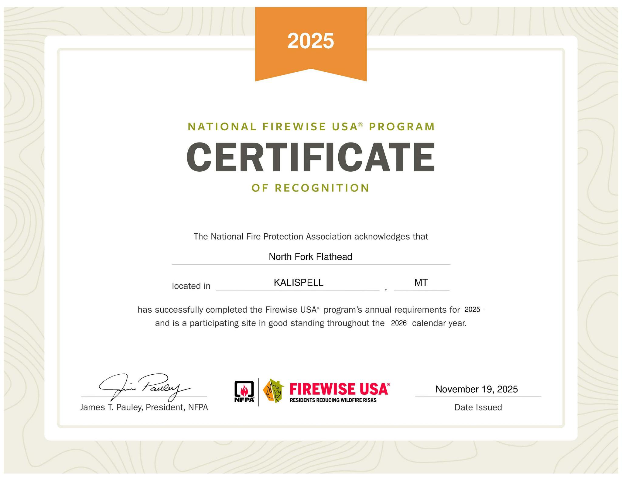
Our Firewise Certification has been Renewed for 2026, and our Firewise Community is in Good Standing!!
We recorded $120,000 in qualifying work, and greatly exceeded the required $16,000 investment.
This translates to about $255 per dwelling, compared to the requirement of $34 per dwelling.
That is simply an indication of the work so many North Forkers are doing to make their structures and surrounding forest more fire resistant.
We appreciate everyone who reported their hours and expenditures last year. Thanks to Suzanne Hildner for gathering all that information! She has big shoes to fill after taking over the data collection from Molly Shepherd, who has done it religiously since our beginning.
If you missed reporting last year, please keep track of the work you do from November 1, 2025 to October 31, 2026 and submit it by November 1, 2026. We will make sure to get it counted! [Suzanne Hildner’s email: sdhildner@icloud.com.]
The North Fork Flathead has been recognized as a Firewise Community since 2006. We look forward to celebrating 20 years of Firewise next year!!
It’s that time again. The US Forest Service is planning on a number of prescribed fires across the Flathead National Forest. They also hope to burn some slash piles here and there. Details are limited, probably because of the government shutdown, but they are not announcing any significant activity in the North Fork.
Here’s the meat of the official press release . . .
Flathead National Forest to Begin Prescribed Fires As favorable weather conditions allow for hazardous fuels reduction work
Kalispell, Mont., October 9, 2025— The Flathead National Forest is planning prescribed fire operations beginning this week, pending all required approvals. We estimate this work to continue through November as weather conditions allow. We use prescribed fires to help reduce overgrown vegetation to help protect local communities, infrastructure and natural resources from wildfires.
Planned prescribed fires for this fall may include:
Spotted Bear Ranger District – 20 acres in the Spotted Bear Mountain area, south of Spotted Bear Ranger Station (broadcast and pile burning).
Swan Lake Ranger District – hazardous fuels reduction work in Beaver Creek and Lindburg areas, Crane Mountain area, and Blacktail Mountain area (pile burning).
Tally Lake Ranger District – 146 acres in the Star Meadows area, west of Whitefish, MT (broadcast and pile burning).
Pile burning across the Flathead National Forest to reduce hazardous fuels in Flathead, Missoula, and Lake counties.
Watch for warning signs along roads near all prescribed fire areas before and during burns. Residents may experience smoke during the prescribed burns. When driving, slow down and turn on your headlights when you encounter smoke on the road. Go to https://fire.airnow.gov/ for detailed information about air quality.
We will evaluate weather conditions in the hours before a burn begins. If conditions warrant, scheduled prescribed fire activities may not commence.
Stay informed about the scheduled prescribed fires through the forest website and social media channels. We will notify county emergency management officials when burning begins.
Do you have a forest that’s located within the boundary below? Do you want to help protect against fire, disease and insects? Then this sounds like an opportunity for you!
This is your last chance to get financial and technical assistance for your property from the NRCS.
Last chance to sign up: October 31, 2025.
Sign up in person at 133 Interstate Ln, Kalispell, MT 59901 or call us
at (406) 752-4242 ext. 3
The following information about wildland fires in the Glacier View Ranger District was received on Thursday, September 3, from Ryan Butler, Acting Fire Management Officer for the district. Thanks, Ryan!
(Note that all these fires are south of Moose Lake and some distance west of the North Fork Road.)
Good Morning,
I wanted to reach out to the North Fork Community to give an update on several fires in the Hallowat/Big creek drainages. Below is a summary of the fires . . .
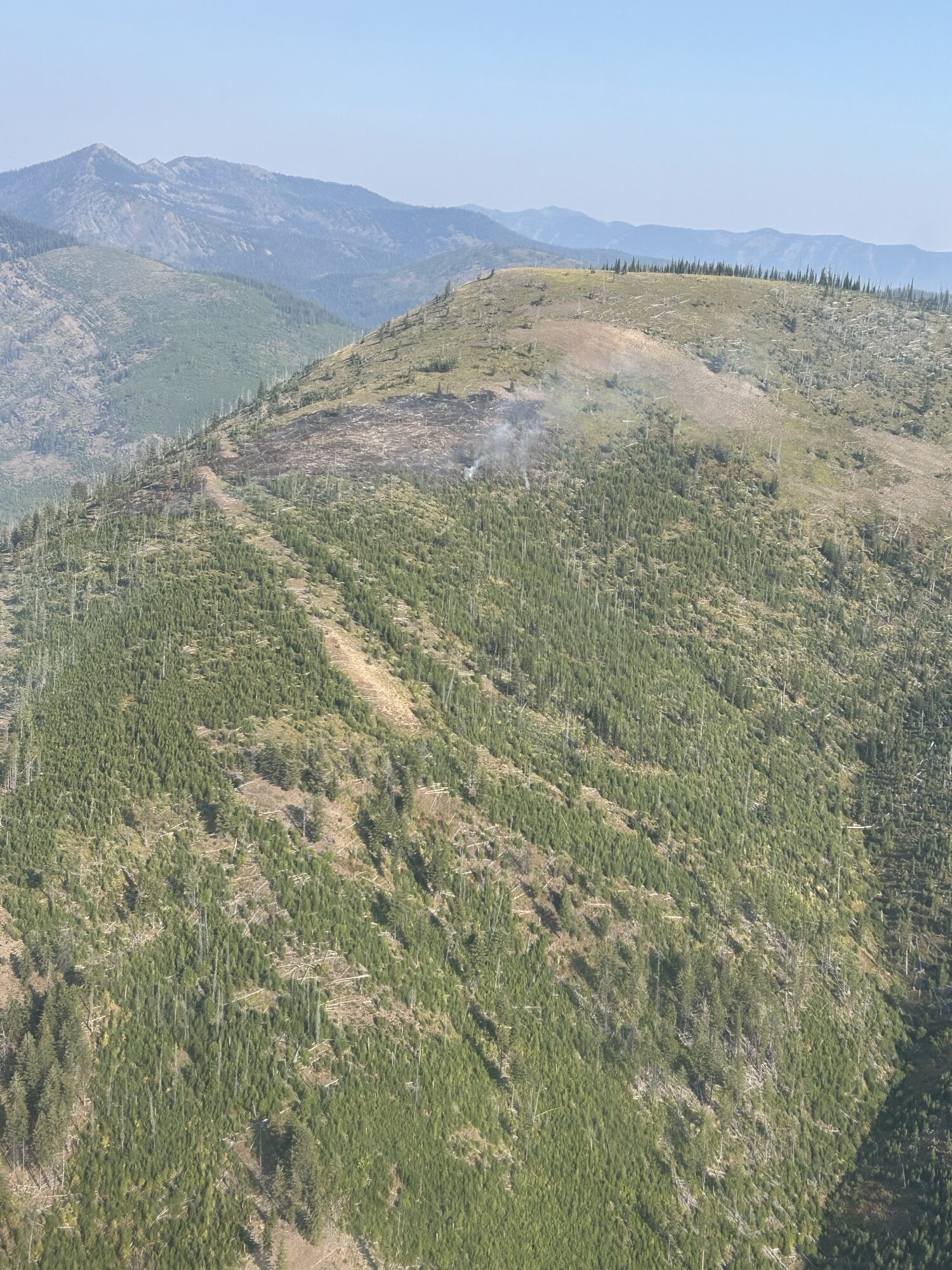
Hallowat Fire, Sep 4, 2025
Hallowat Fire (See attached photo. The attached map shows location of all three fires) Discovery date/time: 9/2/25 @1630 Location: Dead Horse Ridge in the Big Creek drainage, Glacier View RD. Size: 3-5 acres
Status: Fire was called in by Huckleberry Lookout. The fire is located on the ridge top within the footprint of the 2001 Moose Fire. Terrain is steep, rugged, and remote with limited access for firefighters and equipment. Fuel type is grass, brush, dead and down logs, and standing snags. Firefighters from the nearby 2025 Moose Fire responded but were unable to engage due to fire behavior and limited access. Air Attack, one Type 2 helicopter, and one Type 1 helicopter responded and delivered buckets until dark on 9/2/25.
Trail #452 is within the area of active fire and should be avoided by the public.
Weather is forecasted to move to a cooler, wetter weather pattern. Based on this and the time of year and fire location, our strategy for the Hallowat fire will be to utilize natural barriers, and trails and roads as containment features. District firefighting resources will be on this fire for the foreseeable future or until we get a season-ending event.
*Note* Smoke from the Hallowat Fire has been visible from the summit of Big Mountain, as well as the summit webcam.
Moose Fire Discovery date/time: 9/1/25 @ 1400 Location: ½ mile west of the junction of Rd 315 and Rd 316, Big Creek drainage, Glacier View RD. Size: 1/4 acre
Status: Staffed with 8 firefighters and 1 type 4 fire engine. Fire has line around it and is contained. Expected to be declared out 09/05/25
Radio Fire Discovery date/time: 9/2/25 @1100 Location: Approx. 1 mile NW of the radio tower on Big Mtn, Glacier View RD. Size: 1/10 acre
Status: Staffed with 4 firefighters. Fire is contained. Expected to be declared out 09/05/25
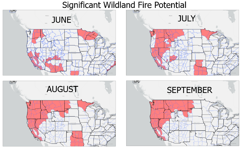
With the fire season starting early this year, it also looks to be a long duration for the Northern Rockies and the Pacific Northwest. Attached is a short four page writeup that explains the forecast for June through September.
The potential for 2025 is similar to the fire years of 2006 (although 2007 was more significant in the Flathead), 2017 and 2021.
What is different this year is that there is no indication of moisture moving in during September – where we usually see either a rainy season-slowing event, or a season-ending rain and snow.
The North Fork has dodged significant fire since 2003. The fires we have had since then have been well-managed and have not had the big runs we saw in 1988, 2001 and 2003.
Be prepared, and hope for the best.
Be sure to attend the Wildland Fire Awareness Training on June 19th, 10 a.m. at Sondreson Community Hall, and the Firewise Day on July 9th, 9:30 a.m. to noon before the Potluck and the Interlocal.
Truck and trailer being consumed by fire on North Fork Road, September 6, 2024 – W. K. Walker
Some excitement the afternoon of Friday, September 6: A brand new F-150 pickup belonging to the contractor working on the road project at the upper end of the North Fork Road caught fire. The vehicle was a total loss, along with the load of road cloth on the trailer it was pulling. Continue reading Spectacular truck fire near Walker’s
According to a recent press release, there are no prescribed burns planned for the North Fork this fall — or in the entire Hungry Horse or Glacier View ranger districts, for that matter. The Spotted Bear, Tally Lake and Swan Lake districts have a few lined up, however. Click on the map for details.
Note that the map does not display “…both landing and hand piles that are not identified on the map which may also be burned when conditions become favorable.” I’m guessing this might include some of the slash and other debris piled at the Ford Schoolhouse site.
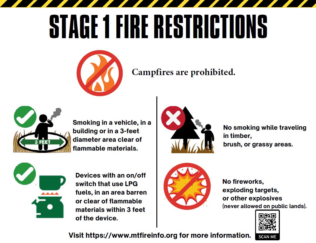
It’s that time again! From the official press release . . .
August 1st, 2024 — Interagency fire managers are implementing Stage I Fire Restrictions that will go into effect at 12:01am Saturday, August 3rd, 2024 across the Flathead National Forest, Kootenai National Forest, Glacier National Park, US Fish and Wildlife Service, Montana Department of Natural Resources and Conservation – Northwestern Land Office, Montana Fish, Wildlife & Parks Region 1, Lincoln County, Flathead County, and Sanders County. Continue reading Northwest Montana Stage 1 Fire Restrictions in effect Saturday August 3 at 12:01 am
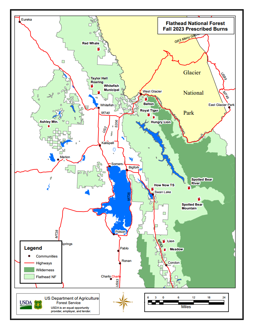
Fall 2023 prescribed burns in the Flathead National Forest
The Flathead National Forest just released its fall list of 13 prescribed burning projects. Only one, the “Red Whale Landscape” burn, is in the North Fork.
As usual, the entire plan depends on weather conditions, air quality issues and, occasionally, whether or not they can get a fire started in the first place.
Here’s the write-up for our local burn . . .
Red Whale Landscape – Approximately 536 acres will be treated with prescribed burning this fall in Moose creek and Moran creek. This project location is in the North Fork of the Flathead about 4 miles northwest of Polebridge. Depending on weather, this burn is planned for mid to late September or early October. The purpose of this project is to help restore a more historical fire regime to the ecosystem, improve wildlife habitat, and reduce hazardous fuels to reduce wildfire risk and aid in potential future fire suppression efforts.