The following information about wildland fires in the Glacier View Ranger District was received on Thursday, September 3, from Ryan Butler, Acting Fire Management Officer for the district. Thanks, Ryan!
(Note that all these fires are south of Moose Lake and some distance west of the North Fork Road.)
Good Morning,
I wanted to reach out to the North Fork Community to give an update on several fires in the Hallowat/Big creek drainages. Below is a summary of the fires . . .
Hallowat Fire, Sep 4, 2025
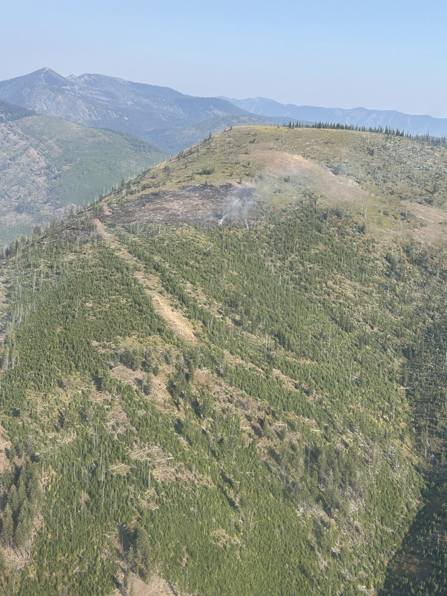
Hallowat Fire (See attached photo. The attached map shows location of all three fires) Discovery date/time: 9/2/25 @1630 Location: Dead Horse Ridge in the Big Creek drainage, Glacier View RD. Size: 3-5 acres
Status: Fire was called in by Huckleberry Lookout. The fire is located on the ridge top within the footprint of the 2001 Moose Fire. Terrain is steep, rugged, and remote with limited access for firefighters and equipment. Fuel type is grass, brush, dead and down logs, and standing snags. Firefighters from the nearby 2025 Moose Fire responded but were unable to engage due to fire behavior and limited access. Air Attack, one Type 2 helicopter, and one Type 1 helicopter responded and delivered buckets until dark on 9/2/25.
Trail #452 is within the area of active fire and should be avoided by the public.
Weather is forecasted to move to a cooler, wetter weather pattern. Based on this and the time of year and fire location, our strategy for the Hallowat fire will be to utilize natural barriers, and trails and roads as containment features. District firefighting resources will be on this fire for the foreseeable future or until we get a season-ending event.
*Note* Smoke from the Hallowat Fire has been visible from the summit of Big Mountain, as well as the summit webcam.
Moose Fire Discovery date/time: 9/1/25 @ 1400 Location: ½ mile west of the junction of Rd 315 and Rd 316, Big Creek drainage, Glacier View RD. Size: 1/4 acre
Status: Staffed with 8 firefighters and 1 type 4 fire engine. Fire has line around it and is contained. Expected to be declared out 09/05/25
Radio Fire Discovery date/time: 9/2/25 @1100 Location: Approx. 1 mile NW of the radio tower on Big Mtn, Glacier View RD. Size: 1/10 acre
Status: Staffed with 4 firefighters. Fire is contained. Expected to be declared out 09/05/25
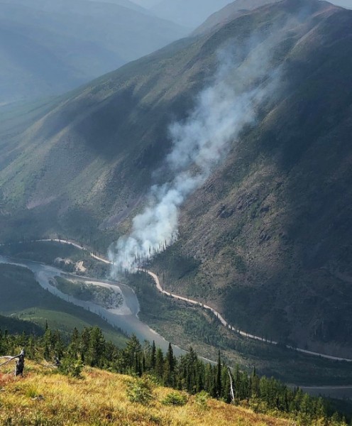
Glacier View Fire from Huckleberry Lookout, August 2, 2023
From the latest press release, here’s the status for fires throughout the Flathead National Forest, including links to supplemental material . . .
Kalispell, MT, August 3, 2023 — As hot and dry weather conditions continue, firefighters continue working to contain several fires on the Flathead National Forest. Area closures are now in place for public and firefighter safety associated with the Tin Soldier Complex, the Ridge Fire, and the Stadium Creek Fire. Fire danger is extreme, and Stage II Fire Restrictions will go into effect at 12:01am Saturday, August 5th, 2023.
The Tin Soldier Complex (comprised of the Sullivan, Kah Mountain, and Bruce Fires) is currently estimated at 2,061 acres. Firefighting crews are engaging in point source protection of values at risk, setting up sprinklers and hose and enhancing fuel breaks with heavy equipment around private property and around the Spotted Bear Ranger Station. Fire personnel are conducting initial assessments and preparations for structure protection.
The Con Kelly Mountain Fire, previously included in the Tin Soldier Complex, is now successfully controlled and firefighters will be transported off-site by aircraft.
The Ridge Fire is now estimated at 633 acres. Due to the hot and dry weather conditions, the fire is actively burning on all sides in steep terrain with heavy dead and down fuels with smoke visible from Highway 2 and Hungry Horse, MT. Firefighting crews are working to establish fuel breaks along FS Road 38 and removing combustible materials around the Desert Mountain communication towers. Aerial resources are assisting firefighting efforts by reducing the fire spread.
The Glacier View Fire is human caused, estimated at 3.5 acres. Firefighters have completed containment line and are now working to reduce heat along the edge of the fire perimeter. The interior area of the fire is still producing smoke but poses no threat at this time.
The Doris Point Fire is estimated at 4 acres (growth of 3.5) based on aerial observation on August 3. The fire is burning on 80-90% slope in thick timber and vegetation with prevalent large-diameter dead trees and is not threatening any values at risk.
The Stadium Creek and Alcove Fires are in and just outside of the Bob Marshall Wilderness Complex, respectively, and are not threatening any values at risk.
The East Fork Fire on the Kootenai National Forest is less than a mile from the boundary of the Flathead National Forest, Tally Lake Ranger District. It is currently estimated at 453 acres with very active fire behavior yesterday, including group torching and spotting in heavy timber and subalpine fir. Firefighting crews will continue to construct indirect line and shaded fuel breaks around the fire perimeter with aircraft working to slow fire behavior while equipment establishes an anchor on the fire.
Area Closures:
Tin Soldier Complex ClosureOrder 01-10-04-23-13: The closure area encompasses the southern portion of the Hungry Horse Reservoir from the Jewel Basin Hiking Area boundary west of the reservoir to the mountain ridgeline from Prospector Mountain along the Great Bear and Bob Marshall Wilderness boundaries to Inspiration Point in section 4 T23N R16W. The waters of Hungry Horse Reservoir within this boundary are included in the closure area.
All roads and trails within the closure are closed to the public, including two additional trails:
NFS Trail #7 (Alpine 7) from the junction with NFS Trail #10 (Six Mile Trail), south to the Junction with NFS Trail #31(Napa Point Trail).
Spotted Bear River Trail #2 from the Wilderness Boundary to its junction with NFS Trail #173 (Pentagon Creek).
NFS Trail #64 and NFS Road 895F are not part of the closure and remain open.
Ridge Fire ClosureOrder 01-10-04-23-14: The closure area encompasses National Forest System (NFS) Road 497 and NFS Road 38 in section 3 T31N R19W, Emery Creek, the Coram Experimental Forest, Desert Mountain, and continues east to the Great Bear Wilderness boundary.
Stadium Creek ClosureOrder 01-10-04-23-15: The closed area encompasses Gorge Creek drainage within the Bob Marshall Wilderness area, including Feather, Inspiration, Gorge, Canyon Trickle, and Stadium Creeks.
All roads and trails within the closure are closed to the public. The closure includes:
Stage II Restrictions will go into effect at 12:01am Saturday, August 5th, 2023, across the Flathead National Forest, Kootenai National Forest, Glacier National Park, US Fish and Wildlife Service, Montana Department of Natural Resources and Conservation – Northwestern Land Office, Montana Fish, Wildlife & Parks Region 1, and Lake County, Lincoln County, Flathead County, and Sanders County.
There are no new fires in the Swan Lake Ranger District. No new fire starts were reported today on the Flathead National Forest as of 2:00pm.
 The following information about wildland fires in the Glacier View Ranger District was received on Thursday, September 3, from Ryan Butler, Acting Fire Management Officer for the district. Thanks, Ryan!