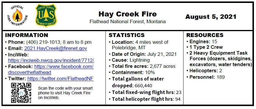
Hay Creek Fire – Incident Update for August 5

INCIDENT UPDATE

The Hay Creek Fire burned actively in dead and down fuels producing increasing smoke on Wednesday, but movement was minimal. A second heavy equipment task force arrived to help assist with operations in the Spruce Creek area. Structure protection personnel and a helitack crew completed structure wrapping of the Coal Ridge Cabin, a remote historic structure without road access. Crews are now staying in the new spike camps in the Home Ranch Bottoms/Cyclone area.
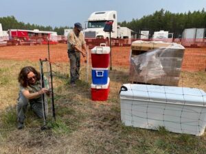
Montana FWP and Flathead National Forest staff install electric fence around possible bear attractants at the Hay Creek Fire Camp on August 4, 2021

Today, crews will continue to secure and connect an avalanche slope on the west end of the fire with Hay Creek Road #376. Other personnel will scout areas north and south of the fire for additional contingency lines. Fuel reduction continues along the southern edge of the fire and on primary and contingency lines between the fire and private lands to the east and northeast. Fire personnel will continue to be in the community sharing information and planning for structure protection.

 Travelers need use extra caution in driving due to fire traffic and road construction in the area. Most of Montana is experiencing EXTREME fire danger; Stage 2 Fire Restrictions are in effect with campfires prohibited. Know Before You Go- Visit www.mtfireinfo.org for additional Montana fire restrictions.

 EVACUATIONS

Evacuation Warnings include all residences east and west of the North Fork Road from Home Ranch Bottoms north to and including Moose Creek Road and the community of Polebridge. Glacier National Park has issued an Evacuation Warning for the North Fork area of Glacier National Park north of Logging Creek. See details at https://go.usa.gov/xFjcA and Current Fire Information – Glacier National Park.

 CLOSURES

Road and trail closures are in place. See details at Inciweb: https://inciweb.nwcg.gov/incident/article/7712/62192/.

 WEATHER AND AIR QUALITY Continue reading Hay Creek Fire – Incident Update for August 5
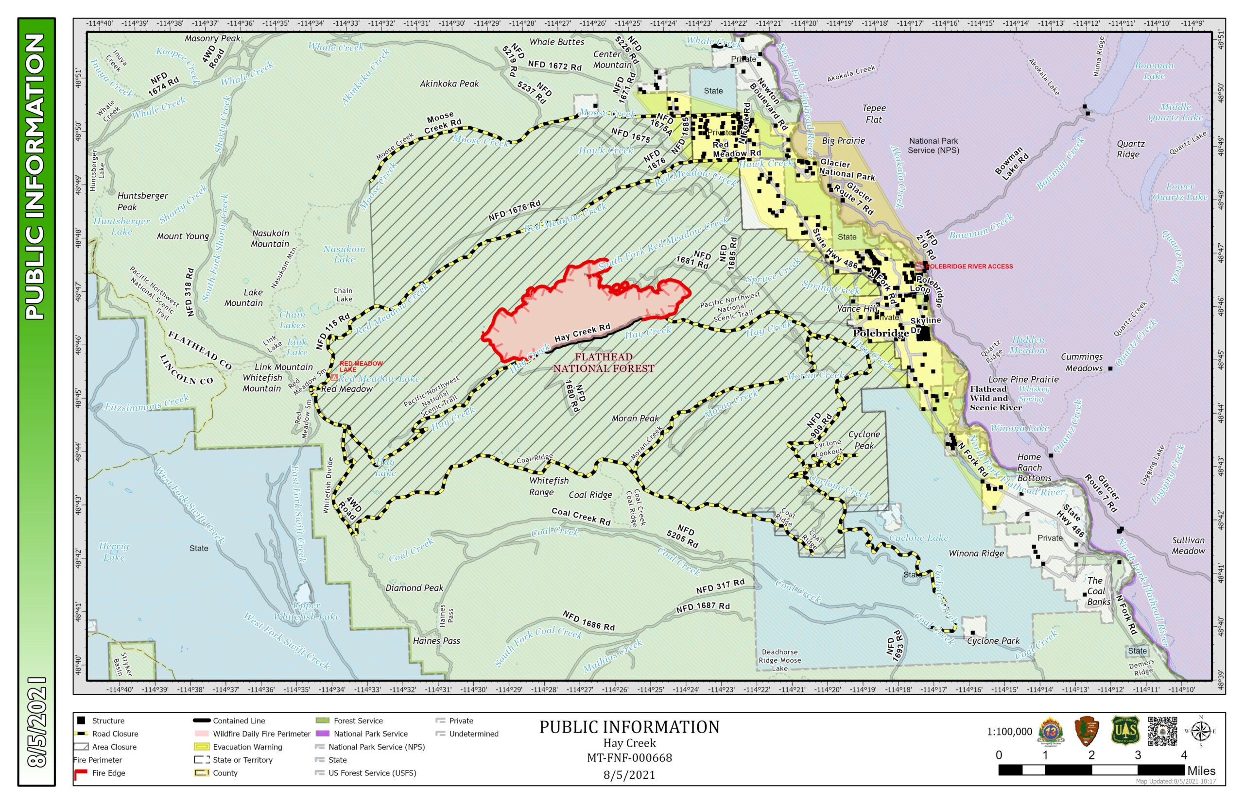
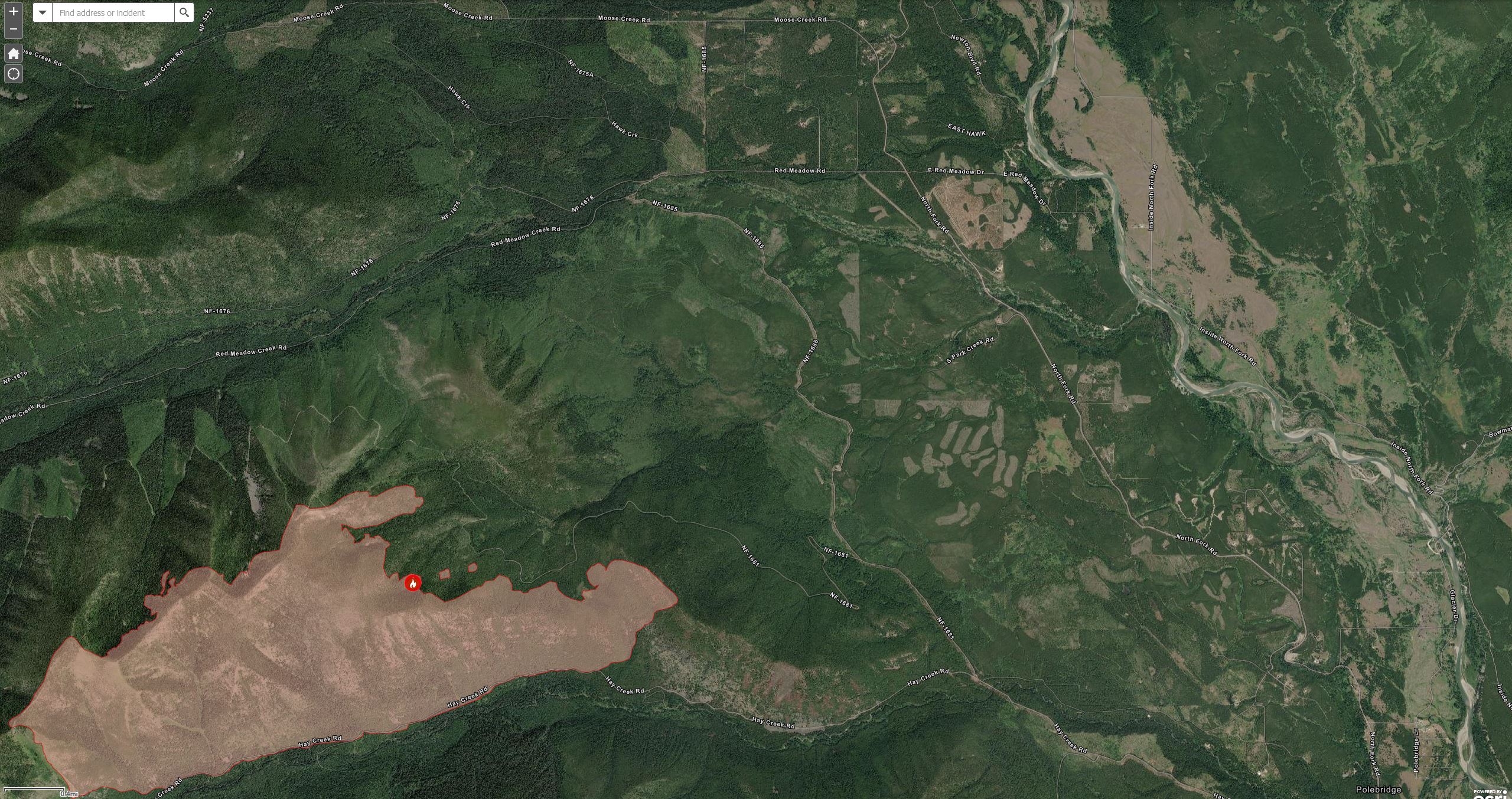
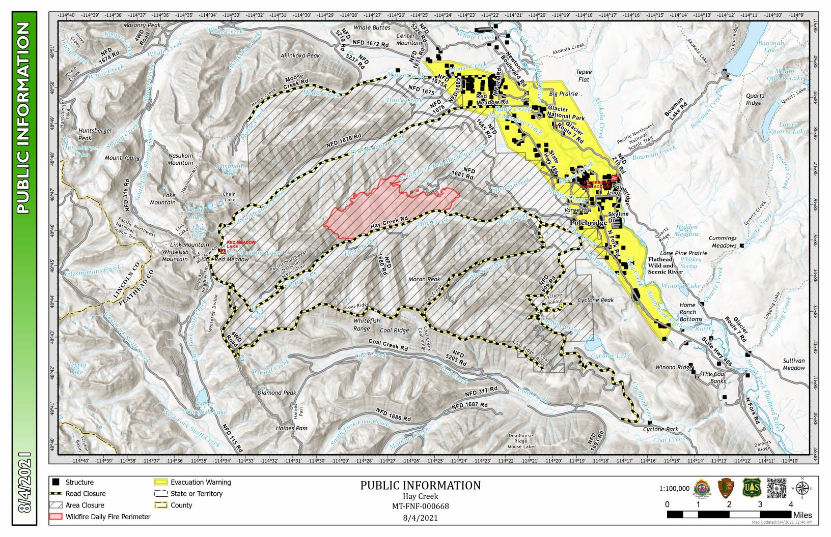
Hay Creek Fire – updated Public Information Map for August 5

Here’s the latest Hay Creek Fire Public Information Map showing fire extent, closures and current evacuation zone boundaries . . .

[Updated at 11am to show the location of the containment line along Hay Creek Road.]

Hay Creek Fire Public Information Map, Aug 5, 2021 (updated)

PDF version: https://nflandowners.org/nflawp/wp-content/uploads/2021/08/Hay-Creek-Fire-Public-Information-Map-Aug-5-2021-updated.pdf

Radio operators needed for Hay Creek Fire!

August 1, 2021 Hay Creek Fire - USFS
August 1, 2021 Hay Creek Fire – USFS

Just received via email from Jack Wise, the Hay Creek Fire Fire team Liaison Officer…

I would like to reach out once again to our cooperators and stakeholders for a request for radio operators. We are looking for folks that know how to use a radio and would like to volunteer (possible pay) to assist us in our communications for the Hay Creek Fire at our Incident Base camp. For more information, please contact our Communications leader, Terry Brinson at 208 510-8331 (interopflorida@gmail.com).

Hay Creek Fire – Incident Update for August 4

INCIDENT UPDATE

There was minimal growth to the fire on Tuesday, as fire activity was tempered by cooler temperatures and higher humidity levels. Smoke continued to be produced on both the east and west sides of the fire, and an infrared scan detected heat around the entire fire perimeter. The Incident Management Team began establishing two spike camps for approximately 100 firefighters in the Home Ranch Bottoms area to reduce travel time to the fire, reducing fatigue and increasing efficiency in operations as crews anticipate future fire fighting needs to control this “sleeping giant.”

Crews will be flown to the Coal Ridge Cabin today to evaluate needs for structure protection and the possible use of structure wrap to protect the historic structure in the event it is reached by fire. Crews are establishing temporary stream crossings to allow fire fighting vehicles to continue to move west on Hay Creek Road #376.

Both hand crews and heavy equipment continue to expand and improve primary and contingency lines in the Spruce Creek and Red Meadow areas. The structure protection group continues to work with local agencies to develop the structure protection plan.

Please exercise caution when driving in the area due to fire fighting traffic and equipment. Most of Montana is experiencing EXTREME fire danger; Stage 2 Fire Restrictions are in effect. Know Before You Go- Visit www.mtfireinfo.org for Montana fire restrictions.

EVACUATIONS 

Evacuation Warnings include all residences east and west of the North Fork Road from Home Ranch Bottoms north to and including Moose Creek Road and the community of Polebridge. Glacier National Park has issued an Evacuation Warning for the North Fork area of Glacier National Park north of Logging Creek. See details at https://go.usa.gov/xFjcA and Current Fire Information – Glacier National Park.

CLOSURES 

Road and trail closures are in place. See details at Inciweb: https://inciweb.nwcg.gov/incident/article/7712/62192/.

WEATHER AND AIR QUALITY

Continue reading Hay Creek Fire – Incident Update for August 4

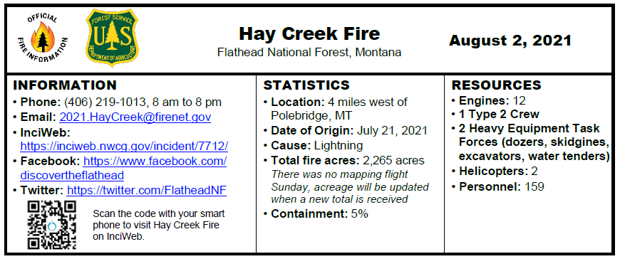
Hay Creek Fire – Incident Update for August 2

INCIDENT UPDATE

The western flank of the fire remained the most active during the burn period on Sunday. Crews continue to prep the Hay Creek Road #376 and evaluate conditions for future firing operations if necessary. Heavy equipment task forces continue their work widening and establishing roads and fuels breaks along primary and contingency lines west of the North Fork Road. A structure protection group was established to assess properties and historic cabins in the North Fork area.

The area received precipitation yesterday evening, quieting fire behavior and slowing the rate of spread. Precipitation can subdue fire behavior in the short term, but overall season trends will likely result in future increased fire activity. Exercise caution when driving in the area due to rainfall and the potential for downed trees due to wind.

A new fire, the Gun Range Fire, was reported along the North Fork Road just north of Columbia Falls Sunday afternoon. Aerial resources from the Hay Creek Fire responded for initial attack assistance.

Most of Montana is experiencing EXTREME fire danger; Stage 2 Fire Restrictions are in effect. Know Before You Go- Visit www.mtfireinfo.org for Montana fire restrictions.  

 EVACUATIONS 

Evacuation Warnings include all residences east and west of the North Fork Road from Home Ranch Bottoms north to and including Moose Creek Road and the community of Polebridge. Glacier National Park has issued an Evacuation Warning for the North Fork area of Glacier National Park north of Logging Creek. See details at https://go.usa.gov/xFjcA and Current Fire Information – Glacier National Park.

CLOSURES 

Road and trail closures are in place. See details at Inciweb: https://inciweb.nwcg.gov/incident/article/7712/62192/.

WEATHER AND AIR QUALITY

Continue reading Hay Creek Fire – Incident Update for August 2

Some hints on reading fire weather forecasts

Since I am following the fire weather forecasts, I had to figure out a few cryptic references. Among them…

CWR is “Chance of Wetting Rain” — how likely it is that you’ll see more than about 0.1 inches of rain.

The “Haines Index” is used to indicate the potential for wildfire growth by measuring the stability and dryness of the air over a fire. Values range from 2 to 6. The smaller the number, the better.

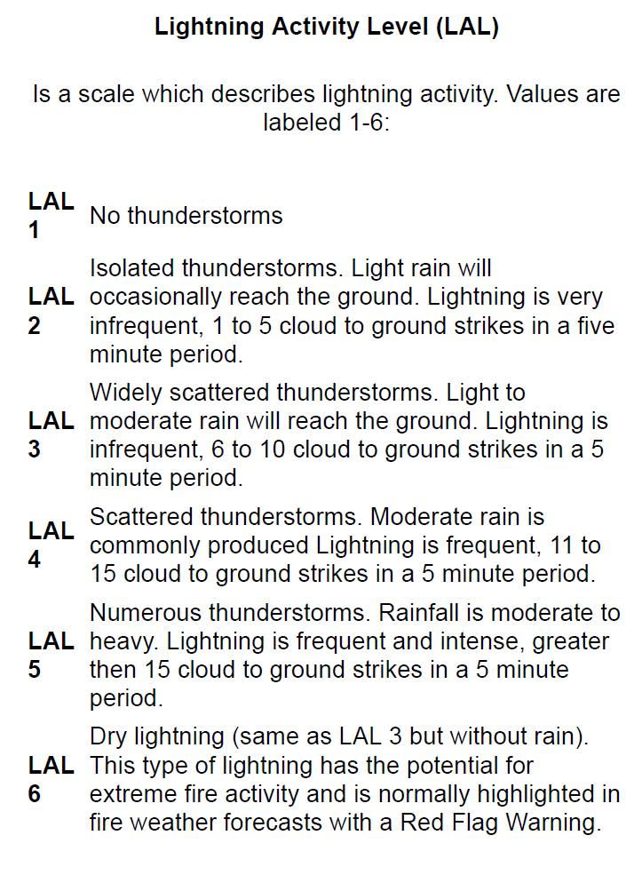
LAL is “Lightning Activity Level.” It ranges from 1 to 6. See below for details but, again, the smaller the number the better when it comes to fire suppression.

LAL - Lightning Activity Level Table
LAL – Lightning Activity Level Table

(PDF of above image)