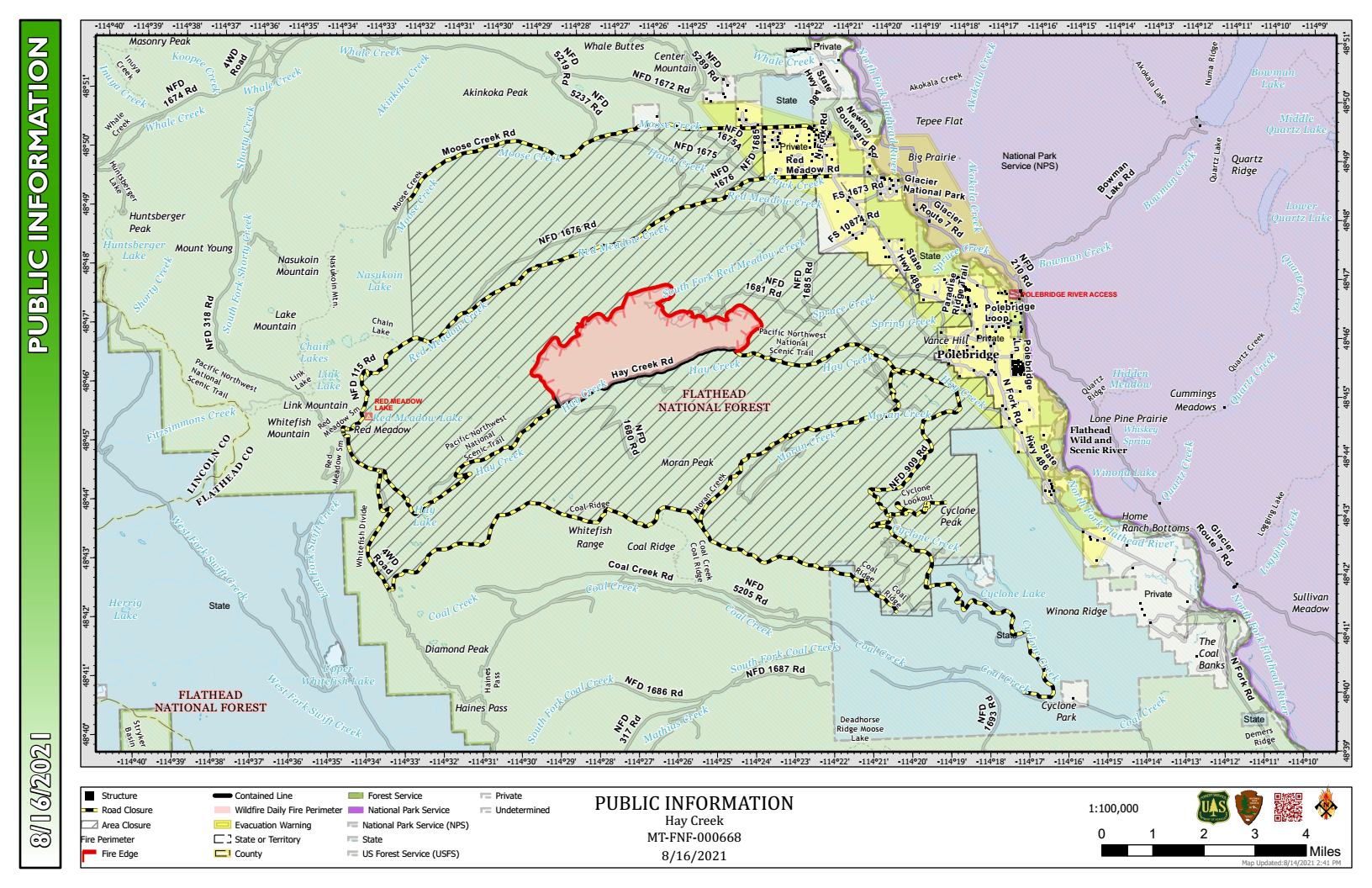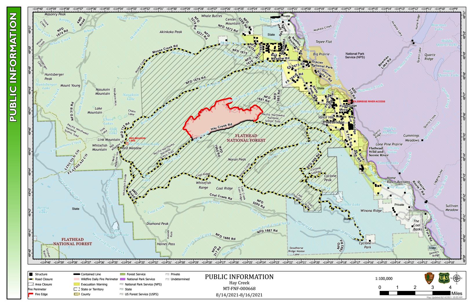
Hay Creek Fire – updated Public Information Map for August 16-17

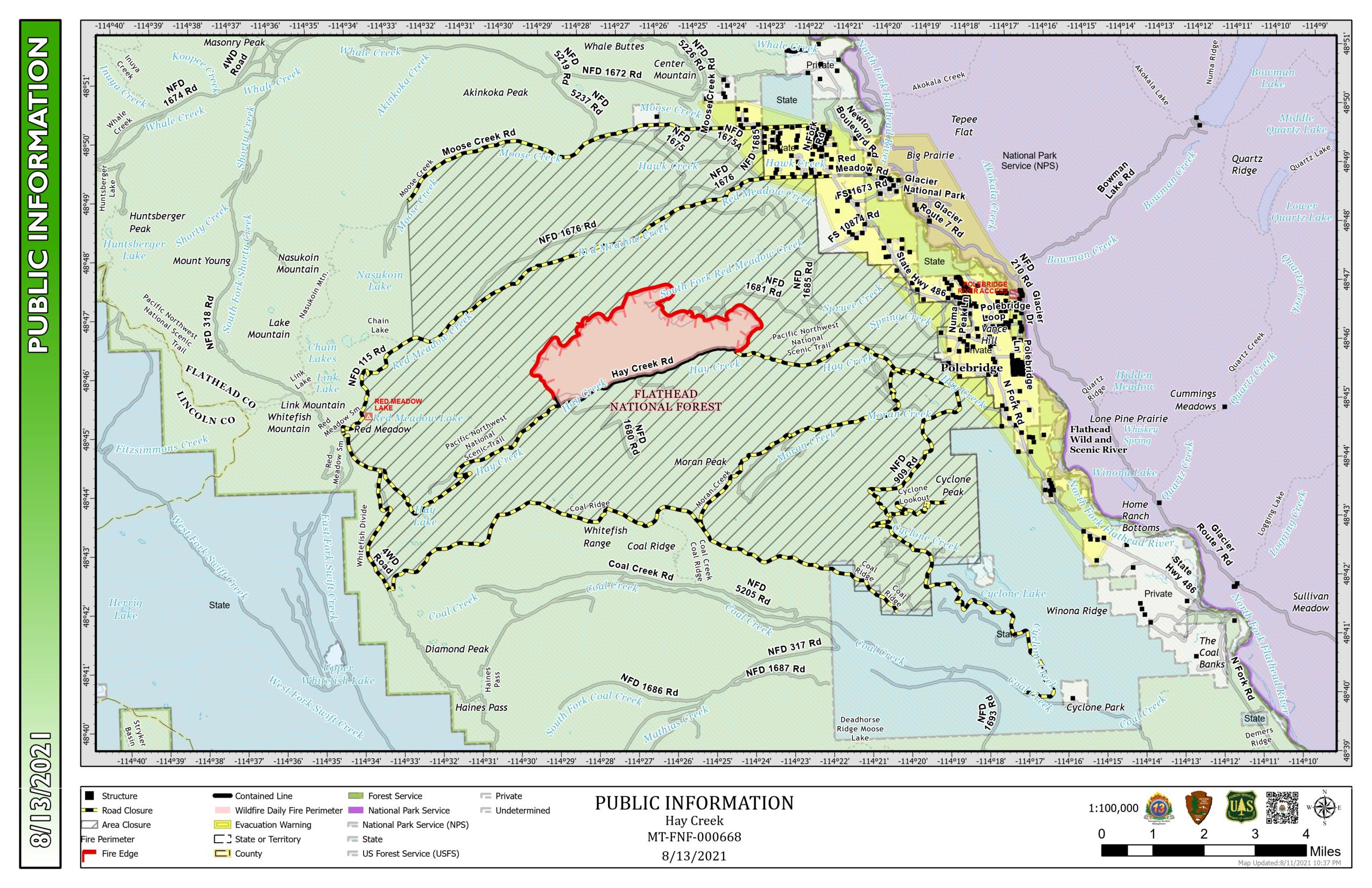
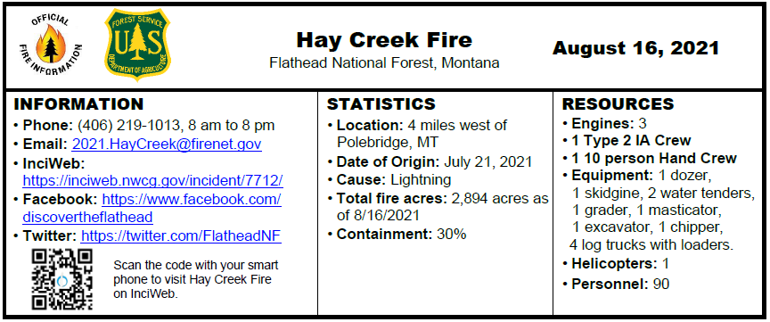
Here’s the latest Hay Creek Fire Public Information Map showing fire extent, closures and current evacuation zone boundaries.

Unless conditions worsen, the Type 3 fire team won’t be putting out a daily report. It will be every couple of days, maybe more if things really settle down.

Hay Creek Fire Public Info Map for August 16-17, 2021

PDF version: https://nflandowners.org/nflawp/wp-content/uploads/2021/08/Hay-Creek-Fire-Public-Info-Map-for-August-16-17-2021.pdf

Hay Creek Fire – Incident Update for August 14

INCIDENT UPDATE

Today, August 14, the local incident command team takes over the Hay Creek Fire. The plan remains the same. Team 13, under Mike Wakowski commanding, would like to thank the North Fork community, the Flathead National Park and Glacier National Park for their welcome and support.

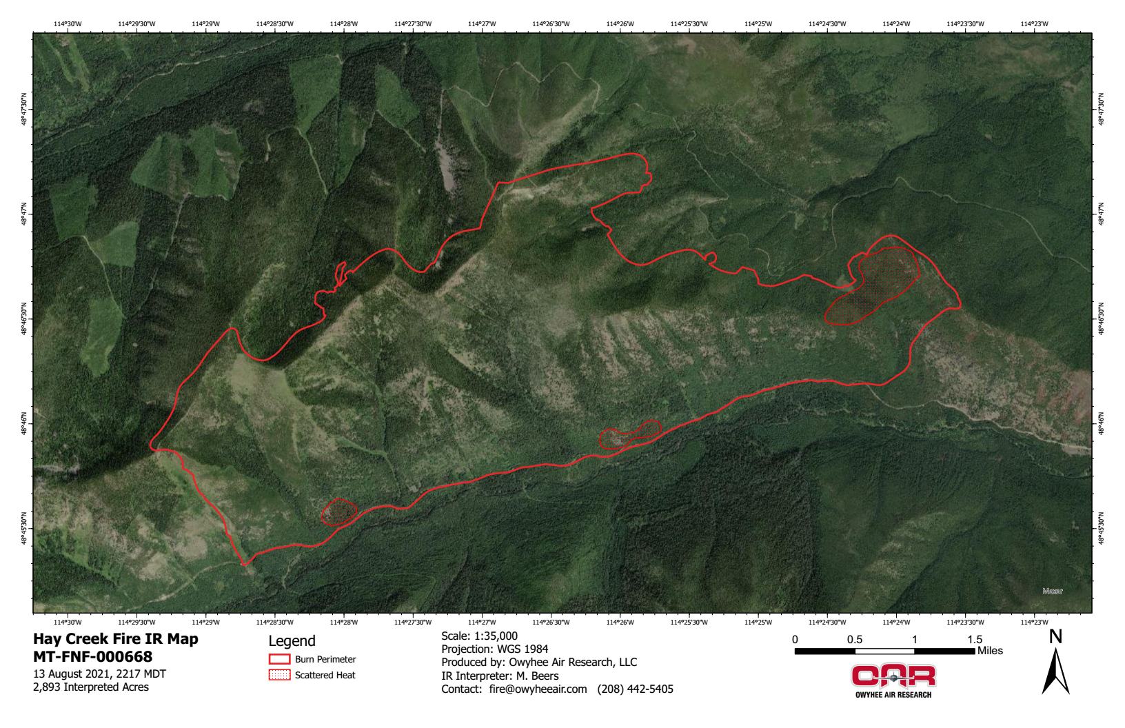
Hay Creek Fire - IR Imagery, Topo - Aug 13, 2021
Hay Creek Fire – IR Imagery, Topo – Aug 13, 2021

Logs continue to be moved off contingency lines and stacked at the Moose Creek Road # 210C. Crews continue to patrol and mop up along the Hay Creek Road # 376. A hand crew and chipper are finishing fuels removal along the Red Meadow Road. Spike camps at the Home Ranch Bottoms and in the Cyclone Peak area have been moved to the incident base in West Glacier.

With warmer and dryer weather, increased smoke from areas of residual heat is expected. A flight is scheduled for today to assess the fire. This information will be updated on Monday, August 16, or as conditions warrant.

Montana is in VERY HIGH fire danger; Stage 2 Fire Restrictions are in effect with campfires prohibited. Know Before You Go- Visit www.mtfireinfo.org for additional Montana fire restrictions.

EVACUATIONS

Evacuation Warnings remain in effect. See details at https://go.usa.gov/xFjcA and Current Fire Information – Glacier National Park.

CLOSURES

Road and trail closures are in place. See details at InciWeb: https://inciweb.nwcg.gov/incident/article/7712/62192/.

WEATHER AND AIR QUALITY

Continue reading Hay Creek Fire – Incident Update for August 14

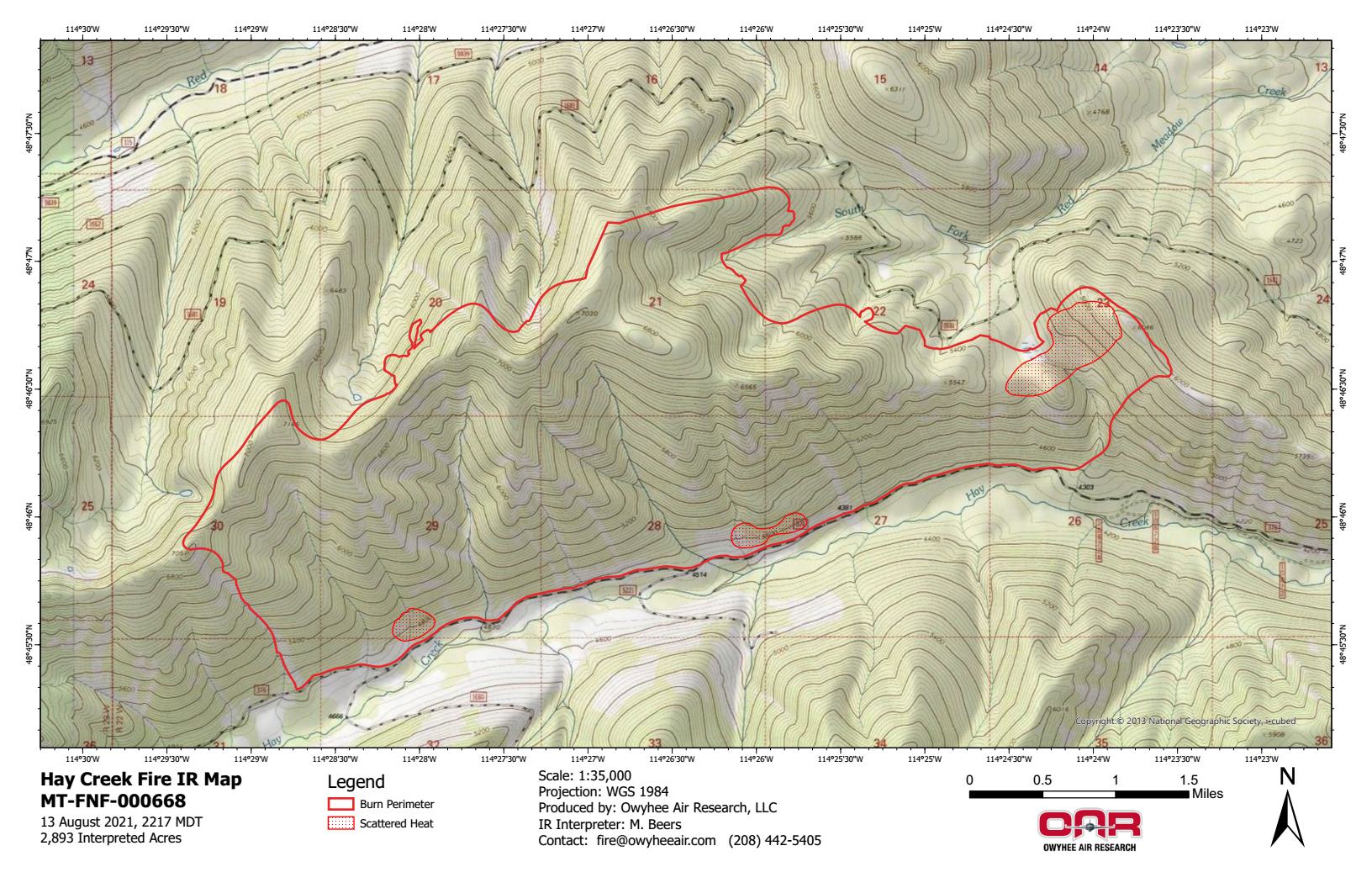
Hay Creek Fire – IR imagery for evening of August 13

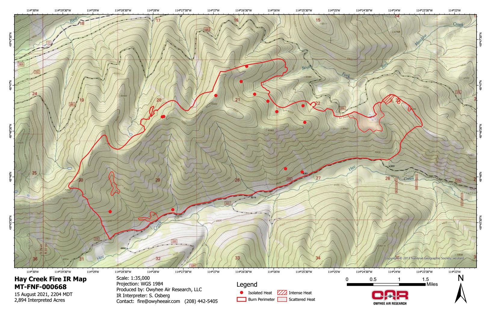
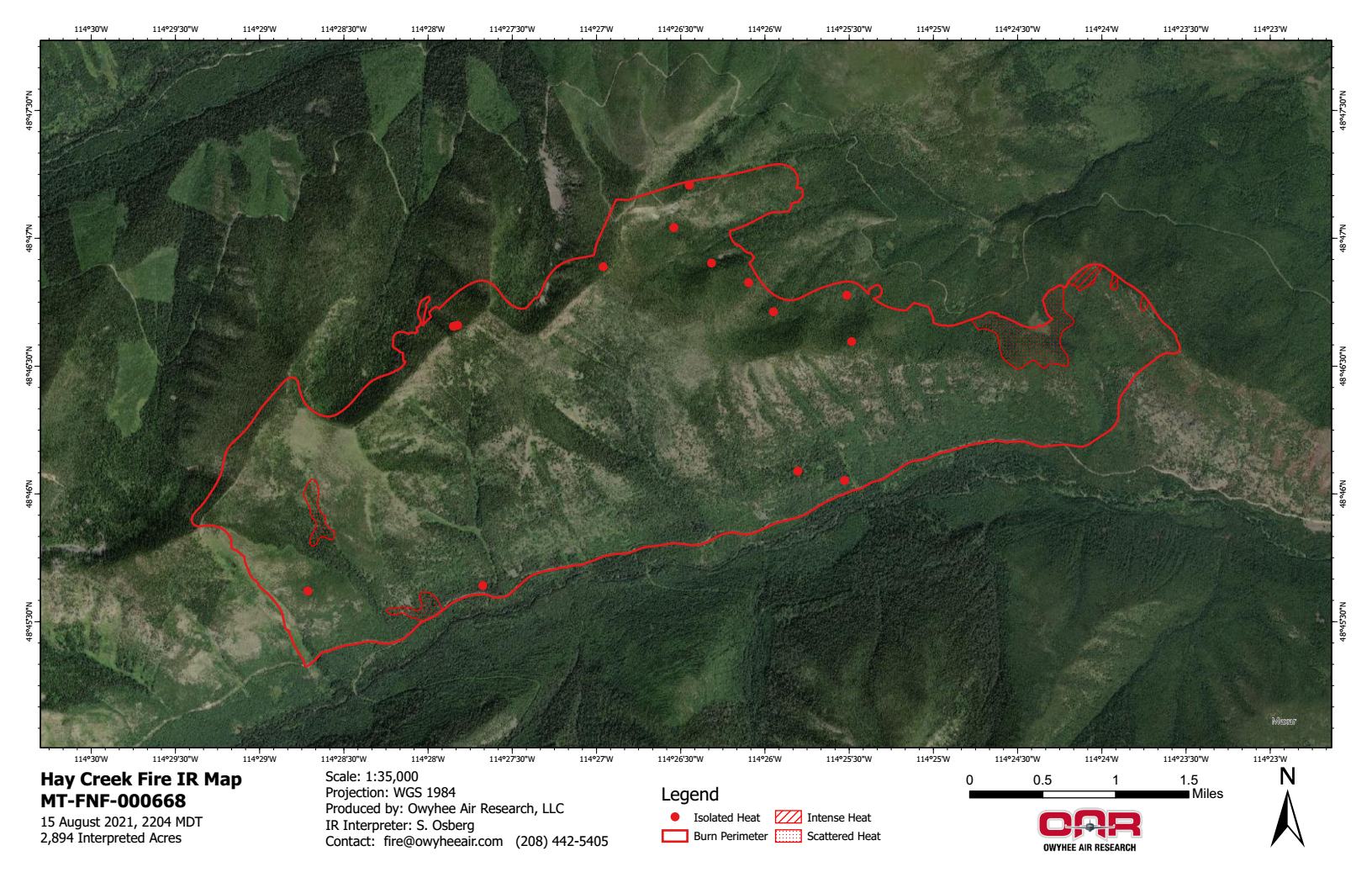
Here are the latest infrared heat maps of the Hay Creek Fire, based on data acquired on August 13, 2021 at 1017pm . . .

Hay Creek Fire - IR Imagery, Topo - Aug 13, 2021
Hay Creek Fire – IR Imagery, Topo – Aug 13, 2021
Hay Creek Fire - IR Imagery, Ortho - Aug 13, 2021
Hay Creek Fire – IR Imagery, Ortho – Aug 13, 2021

PDF versions:
https://nflandowners.org/nflawp/wp-content/uploads/2021/08/Hay-Creek-Fire-IR-Imagery-Topo-Aug-13-2021.pdf
https://nflandowners.org/nflawp/wp-content/uploads/2021/08/Hay-Creek-Fire-IR-Imagery-Ortho-Aug-13-2021.pdf

Hay Creek Fire – Incident Update for August 13

INCIDENT UPDATE

Today, August 13 there will be a transition meeting as the California Incident Management Team 13 turns over control to a local team. The fire is being managed under a full suppression strategy.

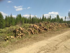
Large log decks on Spruce Creek Road, Hay Creek Fire, August 12, 2021 - USFS
Large log decks on Spruce Creek Road, Hay Creek Fire, August 12, 2021 – USFS

With warmer conditions on Thursday, a few smokes in the SW corner off the Hay Creek Road were mopped up by crews. Yesterday, air operations supported a flight to repair wrap on the Coal Ridge Lookout Cabin, after high winds tore off some of the original protection on the roof. The county grader and 2 water tenders ordered by the fire worked on improving the Hay Creek Road yesterday. Fuel reduction off the Red Meadow Road is close to completion.

A recon flight with the incoming local Incident Commander took place yesterday, and two incident Black Hawk helicopters were loaned to the Haystack and South Yaak fires. Today, operations will take a flight to get eyes on the fire.

Montana is in VERY HIGH fire danger; Stage 2 Fire Restrictions are in effect with campfires prohibited. Know Before You Go- Visit www.mtfireinfo.org for additional Montana fire restrictions.

EVACUATIONS

Evacuation Warnings remain in effect. See details at https://go.usa.gov/xFjcA and Current Fire Information – Glacier National Park.

CLOSURES

Road and trail closures are in place. See details at InciWeb: https://inciweb.nwcg.gov/incident/article/7712/62192/.

WEATHER AND AIR QUALITY

Continue reading Hay Creek Fire – Incident Update for August 13

Hay Creek Fire – Incident Update for August 12

INCIDENT UPDATE

Friday, August 13 will be a day of transition, as the California Incident Management Team 13 turns over control to a local team. The fire is being managed under a full suppression strategy. Last night’s community meeting at Sondreson Hall was well attended and well received.

RAWS site located near Polebridge, MT, August 10, 2021 - USFS
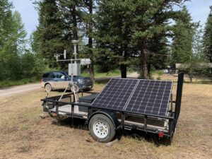
RAWS (Remote Automatic Weather Station) site located near Polebridge, MT, August 10, 2021 – USFS

Fuel reduction work on the Red Meadow road will be completed by tomorrow. Primary indirect fireline in the Spruce Creek area has yielded 130 loads of logs to date, that are staged on the Moose Creek and Red Meadow Roads. A county grader and two water tenders were ordered by the fire. Eleven miles of the North Fork Road has been graded, focusing on sections that have not been treated for dust abatement. Forest roads being use by the fire will be graded next.

An infrared flight last night showed minimal heat in the fire, still focused on the SW and SE corners off the Hay Creek Road. Minimal fire activity is expected again today. Relative humidity remains good, with fuels drying out slowly. Aviation assets from the Hay Creek Fire have supported 6 other fires in the state to date.

Montana is in VERY HIGH fire danger; Stage 2 Fire Restrictions are in effect with campfires prohibited. Know Before You Go- Visit www.mtfireinfo.org for additional Montana fire restrictions.

EVACUATIONS

Evacuation Warnings remain in effect. See details at https://go.usa.gov/xFjcA and Current Fire Information – Glacier National Park.

CLOSURES

Road and trail closures are in place. See details at InciWeb: https://inciweb.nwcg.gov/incident/article/7712/62192/.

WEATHER AND AIR QUALITY

Continue reading Hay Creek Fire – Incident Update for August 12

Hay Creek Fire – updated Public Information Map for August 12

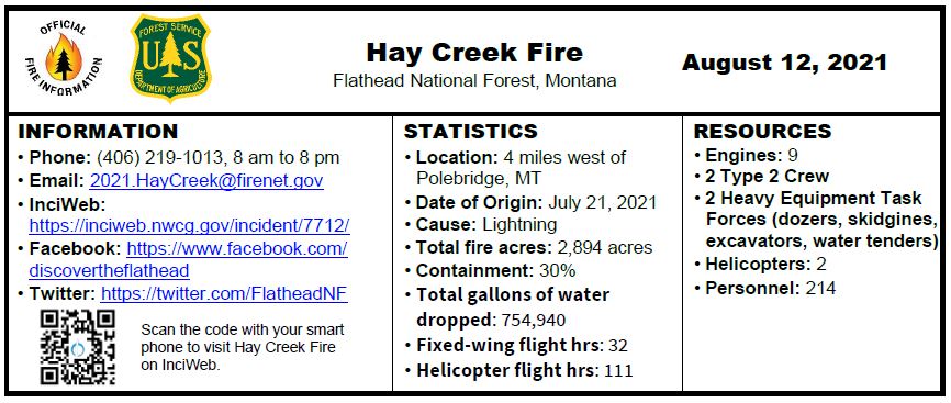
Here’s the latest Hay Creek Fire Public Information Map showing fire extent, closures and current evacuation zone boundaries. Note that containment is now 30% . . .

Hay Creek Fire Public Info Map for August 12, 2021

PDF version: https://nflandowners.org/nflawp/wp-content/uploads/2021/08/Hay-Creek-Fire-Public-Info-Map-for-August-12-2021.pdf

Hay Creek Fire – Incident Update for August 11

INCIDENT UPDATE

A community meeting is being held at the Sondreson Hall today, August 11, at 6:00 pm.

Friday, August 13 will be a day of transition, as the California Incident Management Team 13 turns over control to a local team. The fire is being managed under a full suppression strategy.

The National Guard has been assisting with return of surplus supplies to the Northern Rockies Interagency Fire Cache in Missoula. Due to a relative humidity of around 40% on Tuesday, there were minimal smokes observed, as fuels are still wet within the fire area.

A feller buncher, a self-propelled machine with a cutting head that can hold more than one stem at a time, has been used to remove trees from contingency lines. The structural protection group will move into Glacier National Park today to continue assessments. Work will also include mopping up along the Hay Creek Road. Minimal fire activity is expected again today, with an average of an inch of rain received recently over the fire.

Montana remains in EXTREME fire danger; Stage 2 Fire Restrictions are in effect with campfires prohibited. Know Before You Go- Visit www.mtfireinfo.org for additional Montana fire restrictions.

EVACUATIONS

Evacuation Warnings include all residences east and west of the North Fork Road from Home Ranch Bottoms north to Moose Creek Road and the community of Polebridge. Glacier National Park has issued an Evacuation Warning for the North Fork area of Glacier National Park north of Logging Creek. See details at https://go.usa.gov/xFjcA and Current Fire Information – Glacier National Park.

CLOSURES

Road and trail closures are in place. See details at InciWeb: https://inciweb.nwcg.gov/incident/article/7712/62192/.

WEATHER AND AIR QUALITY

Sunny skies with warmer temperatures and decreased winds at 10 to 15 mph are expected today. Look for highs in the 70’s with some valley bottoms rising into the lower 80’s. A wind shift to the northeast is expected tonight through Thursday night, before turning back to the SW on Friday.

Due to fire traffic and road construction in the area, travelers should drive defensively. For the most current fire weather forecast go to https://www.weather.gov/wrh/fire?wfo=mso. For smoke and air quality go to http://svc.mt.gov/deq/todaysair/. For current visibility in Glacier NP see https://www.nps.gov/glac/learn/photosmultimedia/webcams.htm.

INCIDENT BACKGROUND

The Hay Creek Fire was reported on the evening of July 21, 2021. It is burning in the North Fork area of the Flathead National Forest at 5,200 – 7,100 feet of elevation. Public and firefighter safety is the number one priority. The fire has no reported injuries to date.

Hay Creek Fire – updated Public Information Map for August 11

Here’s the latest Hay Creek Fire Public Information Map showing fire extent, closures and current evacuation zone boundaries. Note that containment is now 30% . . .

Hay Creek Fire – updated Public Information Map for August 11

PDF version: https://nflandowners.org/nflawp/wp-content/uploads/2021/08/Hay-Creek-Fire-–-updated-Public-Information-Map-for-August-11.pdf