Hay Creek Fire – Incident Update for July 28

(PDF version of this document: 2021-07-28-HayCreek-FNF-Update.pdf)
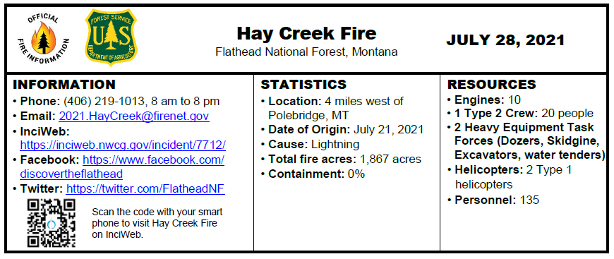
INCIDENT UPDATE

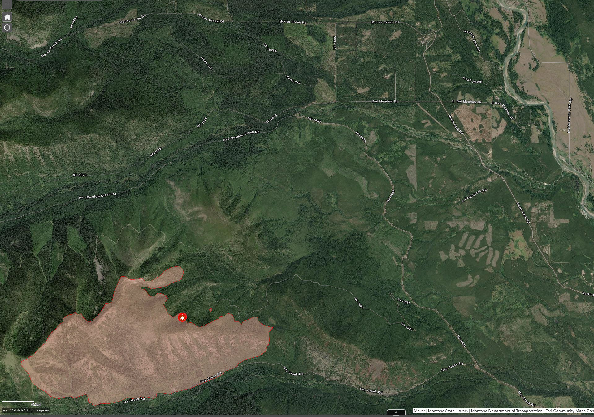
On Tuesday, afternoon cloud cover moderated fire activity during the burn period for a second day. Downslope winds from the weather cell that moved through yesterday evening pushed the fire toward the Hay Creek Road on the southwest flank; today’s weather may provide an opportunity for firefighters to engage in firing operations to burn out the consumable fuels remaining between the Hay Creek Road and the perimeters of the main fire.

Crews were successful in laying approx. 7,000 feet of hose along the Hay Creek Road Tuesday, holding this line remains the priority objective for the current operational period. Heavy equipment task forces will continue work to widen existing roads to connect past silvicultural forest treatments and build contingency lines.

Monsoonal moisture from the southeast has led to increased humidity levels. However, weather trends are still seasonally hot and dry… active fire behavior will continue to be expected overnight.

EVACUATIONS

The Flathead County Sheriff’s department has expanded the phased Evacuation Warning to include all residences east and west of the North Fork Road from Home Ranch Bottoms north to and including Moose Creek Road and the community of Polebridge. Glacier National Park (NP) has issued an Evacuation Warning for the North Fork area of Glacier NP north of Logging Creek. See details at https://go.usa.gov/xFjcA and Current Fire Information – Glacier National Park.

CLOSURES

Road and trail closures are in place. See details at Inciweb: https://go.usa.gov/xFjcC.

WEATHER AND AIR QUALITY

Continue reading Hay Creek Fire – Incident Update for July 28
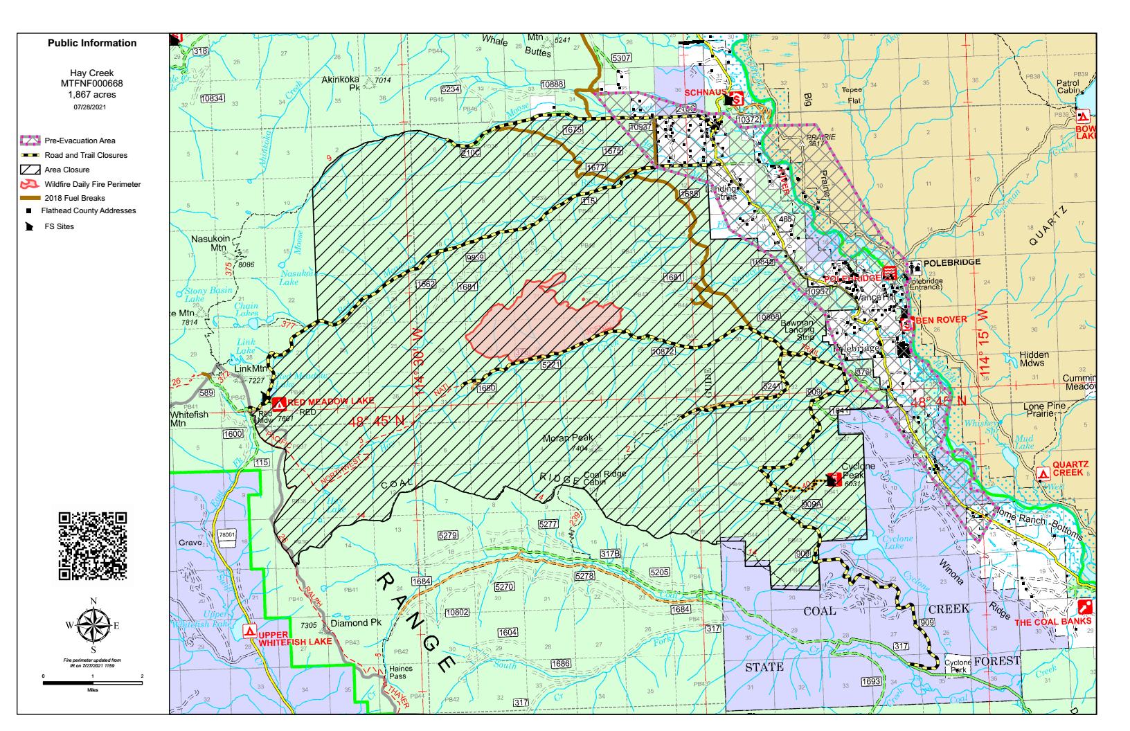
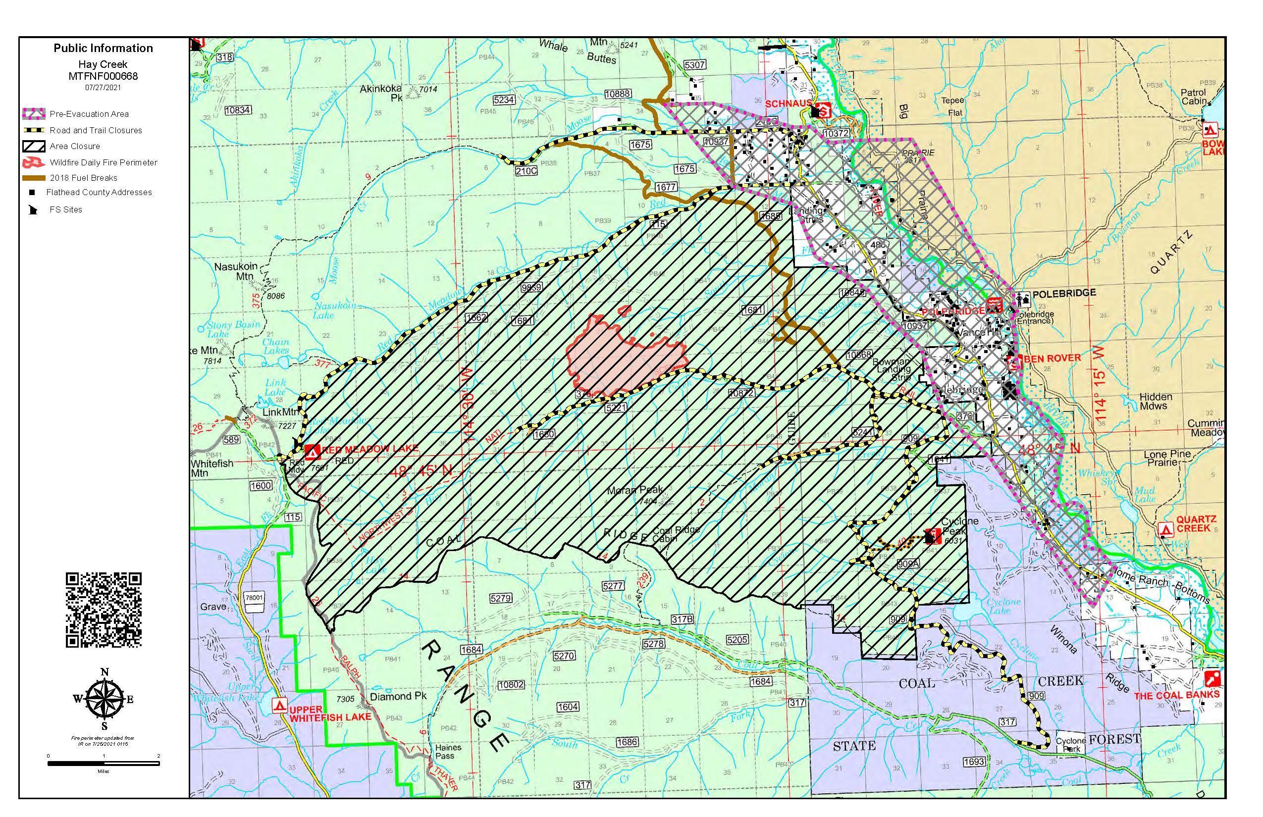
Hay Creek Fire – updated Public Information Map for July 28

Here’s the latest Hay Creek Fire Public Information Map showing fire extent, closures and current evacuation zone boundaries. The main change from yesterday’s map is the inclusion of a section of the Moose Creek drainage in the “Area Closure” zone . . .

July 28, 2021 Hay Creek Fire Map

PDF version: https://nflandowners.org/nflawp/wp-content/uploads/2021/07/July-28-2021-Hay-Creek-Fire-Map.pdf.

Glacier Park offers free transit to residents under pre-evacuation orders

For North Forkers under pre-evacuation orders, here is some very good news from Pete Webster, Acting Superintendent, Glacier National Park. Short version: If you are under pre-evacuation orders, you can get a temporary permit at West Glacier that will let you travel both ways on the Camas Road.

Read on…

Here is a message to share with the North Fork community.

We have been communicating with the Hay Creek Fire Incident Team, Forest Service, and Flathead County on fire conditions and projections, as well as pre-evacuation warning needs. We recognize the pre-evacuation warning is an early notice for folks to prepare for actual evacuation. While actual evacuation may be days or weeks away, pre-evacuation may require several trips back and forth to North Fork properties. As such we have come up with a system to support pre-evacuation travel needs that includes Camas Road for North Fork residents within the pre-evacuation warning zone. Those qualifying residents who identify themselves at West Glacier as pre-evacuation residents will be issued a temporary permit at the West Entrance that will let them travel Camas Road each way. [emphasis added]

Residents do need to recognize that traffic at West Glacier will be heavy at times, MDT US-2 construction has been active at West Glacier, and the Camas Road construction has delays and may not be easy travel as well. My understanding is the fire incident will be grading and providing dust abatement on the bad section of the North Fork Road south of the Camas Bridge, beginning this weekend perhaps.

Monday-Thursday nighttime closures on Camas Road will remain in effect for public traffic 7pm-6am, including pre-evacuation travel for North Fork residents. Although do note, the fire incident team and the evacuation team are coordinated with the Camas construction, so the nighttime Camas closure can be adjusted to support emergency egress should that be necessary.

We are paying close attention and are in direct communication with all aspects of the Hay Creek Fire.

Thank you,

Pete Webster
Acting Superintendent
Glacier National Park

Fuel breaks keep Hay Creek Fire hemmed in near Glacier Park

Hay Creek Fire burning up against Hay Creek Road west of Polebridge, July 26, 2021 - USFS
Hay Creek Fire burning up against Hay Creek Road west of Polebridge, July 26, 2021 – USFS

Here’s a good summary of the wildland fires in the area . . .

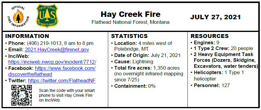
Fire crews battling a 1,350-acre blaze near the community of Polebridge are working to keep the lightning-sparked fire hemmed in against Hay Creek Road and existing fuel breaks.

Dubbed the Hay Creek Fire for its location in the Hay Creek drainage west of the North Fork Flathead River and Glacier National Park, the fire was aided by cloud cover on Monday, when fire officials reported moderate activity and growth. The fire remained active on its west flank, however, exhibiting isolated and group tree torching, as well as short wind-driven crown runs.

Continue reading . . .

Hay Creek Fire – updated Public Information Map for July 27

Here’s the latest Hay Creek Fire Public Information Map showing fire extent, closures and current evacuation zone boundaries. The main change from yesterday’s map is the closure of Moose Creek Road…

Public Information Map – Hay Creek Fire, July 27, 2021

PDF version: https://nflandowners.org/nflawp/wp-content/uploads/2021/07/July-27-2021-Hay-Creek-Fire-Map.pdf.

Hay Creek Fire – Incident Update for July 27

(PDF version of this document: 2021-07-27-HayCreek-FNF-Update.pdf)

INCIDENT UPDATE

On Monday, afternoon cloud cover moderated fire activity. The fire remained active on the west flank, exhibiting isolated and group tree torching and short wind-driven crown runs. The priority objective is holding the line at the Hay Creek Road. Crews are laying hose and will potentially initiate firing operations to burn the remaining available fuels along the road if conditions allow. Spot fires to the south of the road were checked by bucket drops for the second day. Heavy equipment task forces will continue work to widen existing roads to connect past silvicultural forest treatments and build contingency lines.

A new spot fire was detected on the lower third of the south facing aspect in front of the east flank, estimated at ¼ acre. The spot is expected to establish and burn out available fuels ahead of the main fire.

Active fire behavior will likely continue to be observed at night due to low humidity and warm evening temperatures.

EVACUATIONS

The Flathead County Sheriff’s department has expanded the phased Evacuation Warning to include all residences east and west of the North Fork Road from Home Ranch Bottoms north to and including Moose Creek Road and the community of Polebridge. Glacier National Park (NP) has issued an Evacuation Warning for the North Fork area of Glacier NP north of Logging Creek. See details at https://go.usa.gov/xFjcA and Current Fire Information – Glacier National Park.

CLOSURES

Road and trail closures are in place. See details at Inciweb: https://go.usa.gov/xFjcC.

WEATHER AND AIR QUALITY

Continue reading Hay Creek Fire – Incident Update for July 27

County to start grading/dust coating lower North Fork Road this week

“It’s an ill wind that blows nobody any good.” As part of the effort to fight the Hay Creek Fire, the Forest Service has come up with funding to grade and dust coat a particularly rough section of the North Fork Road.

According to a note from Travis Glidewell, Flathead County Road and Bridge Supervisor, the county is about to start grading and dust coating the North Fork Road between end-of-pavement and the Camas intersection. The prep work will be accomplished this week, with “dust oil” (i.e., magnesium chloride) being applied Saturday, July 31.

Expansion of evacuation warning issued for the Hay Creek Fire

Flathead County OES LogoFOR IMMEDIATE RELEASE

Kalispell, MT, July 26, 2021 – Flathead County Sheriff’s Office has expanded the Evacuation Warning in the North Fork area. Sheriff Deputies have been systematically notifying residents in the expanded Evacuation Warning area over the weekend, and throughout today.

Please see the attached Hay Creek Fire Evacuation Warning Map dated 26JUL2021.

An Evacuation Warning means there is a potential threat to life and/or property. This warning is issued to give residents time to prepare for a possible evacuation. Residents & Visitors who require additional time to evacuate or need to move pets or livestock are advised to begin the evacuation process now.

Hay Creek Fire Evacuation Warning Map, July 26, 2021

Hay Creek Fire — goodies for firefighters

July 23, 2021 Hay Creek Fire Photo - USFS

Several people have asked me how to do nice things for the folks working the Hay Creek Fire. Here’s the word from Diane Sine, the Fire Information Officer . . .

“There will be a fire camp set up by the West Glacier KOA starting tomorrow [July 27], and that would be the place folks could drop off any goodies. Everyone working up the North Fork will either be sleeping there or showing up there for briefings, whether day crews or night crews.”
“Firefighters also always appreciate thank you signs or posters, if that’s the sort of thing that anyone would enjoy making. In addition, if folks ever want to recognize firefighters, the organizations we steer them toward are their local volunteer fire departments and https://wffoundation.org/.”