First Aid/CPR/AED Course June 16

First Aid SignageREMINDER: Bob Lee will be giving his well-regarded First Aid/CPR/AED class in the North Fork again this spring. It is an all-day course, starting at 9:00am and wrapping up by 4:00pm. The date is Tuesday, June 16. The course will be held at Sondreson Hall. Cost should  be $45/person.

With a course size limit of 10 people, maintaining appropriate social distancing shouldn’t be a problem.

Contact Bill Walker, 406-407-2764 or wkwalker@nvdi.com to sign up for the course.

Note! Starting last year, the certification cards were distributed electronically. The folks sending the cards insist that every recipient have a unique email address. I.e., if you share an email address with someone else and you are both attending the course, one of you would need to pick up a second address. I can hand out temporary course email addresses if needed, just let me know.

(If something goes awry, the fallback date for the First Aid/CPR/AED Class is June 23rd. I doubt we’ll use it.)

Latest bear update from Tim Manley

Bear Travel Map - May 28-30Here’s the latest North Fork bear information from Tim Manley, Grizzly Bear Management Specialist for Montana Fish, Wildlife & Parks. It was posted to Facebook on Sunday, May 31…

The subadult male I released at the border went immediately west to Fortine. He got into garbage and bird feeders. He was recaptured and killed.

The two females I released in Whale Creek.. also went west to the Fortine, Trego, and Stryker areas. They are hanging around a few residences and getting bird feeders and maybe garbage. No trapping effort for them right now.

The adult male that was from Helmville and released in Coal Creek is now over southeast of Babb outside of Glacier Park. He was photographed near Trail Creek following the scraggly female. He then went into BC northeast of Starvation Peak. He was photographed at a rub tree with a remote camera by BC grizzly bear researchers. That was on May 28th. In the last two days he traveled 48 miles… into Alberta, east of Waterton Lake and then south and was last known to be on the Blackfeet Reservation southeast of Babb.

I attached a map so you can see his travels from May 28th to May 30th.

They rarely stay where we release them…

Latest bear update from Tim Manley

Momma grizzly and her cubsHere’s the latest North Fork bear information from Tim Manley, Grizzly Bear Management Specialist for Montana Fish, Wildlife & Parks. It was posted to Facebook on Saturday, May 9 at about 7am…

Bear update… good morning. Sorry for the long post… I just wanted to provide an update on bears. We will put out a press release but that might take several days.

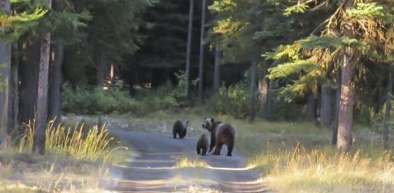
Two days ago we captured three 3-year old grizzly bears along the NW edge of Swan Lk. This spring they had been bouncing around between Ferndale and Woods Bay. Our first reports were from last year when they were eating grass in yards. They were also in the fruit orchards and were seen at Yellow Bay and Finley Point along Flathead Lake.

A couple of weeks ago we got reports of them getting into unsecured garbage at Woods Bay. They also got bird seed and hummingbird feeders on porches. After several days of trapping we captured them.

My thought was to release them up Spotted Bear River. Due to snow on the roads we weren’t able to go down the reservoir or get to a release site up the Middle Fork.

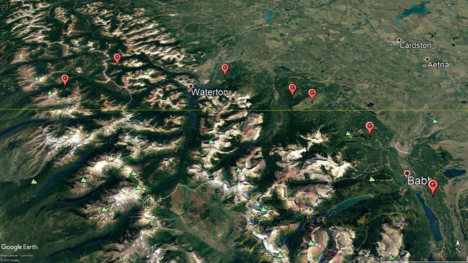
After consulting with the FS and USFWS we decided to release them in the North Fork. Yesterday we released the two females (173 lbs and 222 lbs) in the Whale Cr drainage. We released the male (241 lbs) at the BC border. All three bears are wearing GPS collars. They haven’t been aggressive at all but definitely are used to being near residences. If they show up at your place, make them leave by safely yelling, banging pots and pans or any of the other approved methods that was in the recent NFLA newsletter.

Also yesterday, in the Blackfoot Valley, Wildlife Services captured two subadult male grizzly bears at a site where a calf had been killed. The first bear was released in Glacier Park at Logan Creek. The second male was released in Coal Cr up the North Fork last night by Jamie Jonkel with MT FWP out of Missoula. Both bears are also wearing GPS collars.

Snow conditions have really reduced our ability to access other relocation sites.

After I got back to the valley, the FS contacted me about a grizzly bear that had fed on and buried a deer carcass in the Big Cr Campground. I was able to contact Jonkel and he picked up the remains of the deer. The decision was made to have people move out of the campground for the weekend and close the gate. The bear will have a couple of nights to return and realize the deer carcass is gone and then move on.

The bear (Oattie) that used to spend time in the field south of Polebridge the last few years is currently 10 miles north of the border.

Lastly, I have not had any more recent reports of the single grizzly that had been observed on the Polebridge Bench.

I didn’t want to wait for the press release to notify you of our activities. Feel free to contact me if you have any questions.

Here’s a video of the male being released at the border: https://www.facebook.com/tim.manley.319/videos/10221922988047890/

[Update on May 11] Just a quick update. I won’t be updating all the bears movements but I wanted to let you know generally where they are since being released. The subadult male we released at the border is now near Review Mountain. The two females we released in Whale Cr are near Center Mtn. and are still together. The male that Jonkel released in Coal Creek is now in Big Creek. Oattie is now 12 miles north in BC.

Tim

An update from the North Fork Patrol

Here’s the latest activity report from the North Fork Patrol, courtesy of Mark Heaphy . . .

All 126 properties were checked at least once and 618 miles were logged.

There were a few places that had downed trees, dented vent stacks, unlocked doors and a damaged screen (due to a bear). All owners were notified.

Expanded touring & guiding on the North Fork: summary of routes, maps, dates and ‘service days’

Flathead National Forest

For those of you interested in more information about the Forest Service special use permits being considered for touring and guiding in the North Fork, Rob Davies passed along a very useful “summary of the routes, maps, dates, and service days that folks asked about at the meeting last Tuesday night.“ (Note that Rob must be working some long hours. I got his email a little after 930pm yesterday evening.)

Read the document here (PDF format)

Forest Service wants to allow expanded touring & guiding on the North Fork

Flathead National Forest

The Flathead National Forest is seeking public comment on a number of “recreation events and services,” several of which would occur on the North Fork. Only a couple of major requests significantly affect the portion of the North Fork north of Big Creek.

The Hungry Horse News has a good write-up on the situation. The items most relevant to the North Fork are quoted below. [Clarifying comments are in brackets.]

“Whitefish Shuttle is seeking a permit to provide guided day-use van tours, biking, and hiking on Forest Service system open roads and trails in the North Fork area of the Hungry Horse-Glacier View Ranger District and west of Highway 93 on the Tally Lake Ranger District. The permit would allow for shuttle services and guided van tours, biking, and hiking and between June 1 and Oct. 31 on various system roads and trails including Forest Service Roads 115 [Red Meadow Rd], 376 [Hay Creek Rd], 909 [road from Hay Creek Rd past Cyclone LO trailhead to Coal Creek Rd], 317 [Coal Creek Rd], 316, 315, 5207 [these last three are the route to Moose Lake, starting at the Big Creek Rd turnoff from the North Fork Rd] and Forest Trails 40 [trail to Cyclone LO] and 266 [Demers Ridge Trail – likely the trailhead near the Camas Road intersection that accesses the ‘quad burn’ trail up Glacier View Mountain].”

“Northwest Adventure Sports is requesting a permit to provide guided ATV tours on “various” open motorized system roads on the Tally Lake and Hungry Horse-Glacier View Ranger Districts. Roads currently requested include Forest Roads 9790, 1658, 316 [Big Creek Rd], 115 [Red Meadow Rd]. The permit would allow for guided trips from June 1 until Oct. 31.”

Also note the following other item of interest:

“Spotted Dog Cycles out of Missoula is seeking a permit to run a “bike packing” tour for one week that would stop in the Red Meadow area one night and then drop down into Polebridge. Owner Joe Riemensnider said the entire tour, which will last six days in July, will cover about 150 miles, but only two are actually in the North Fork.”

The deadline for comments is May 1, although this may be extended. Please read the full official announcement document for details on how to submit comments for the various projects.

Read more at the Hungry Horse News . . .

Read the official Forest Service announcement here . . .

Forest Service seeking public comment on the Frozen Moose Project

The Forest Service has big plans for the upper North Fork — including a lot of forestry and restoration work . . .

The Glacier View District of the Flathead National Forest is asking for public comment on the Frozen Moose Project. The project area is on National Forest System lands from Red Meadow Creek to the Canadian Border. The project proposes several types of management activities to reduce fuels in the wildland-urban interface, improve the resiliency of vegetative communities, improve aquatic ecosystems, and provide a mix of forest products. These proposed activities include 3,552 acres of commercial vegetation treatment, 4,630 acres of noncommercial vegetation treatments, road management activities, and other aquatic restoration activities.

Maps of the proposed action, detailed descriptions of activities, and information on how to comment can be accessed at the project Web site: www.fs.usda.gov/project/?project=57310. Hard copies of the proposed action documents are available by request or can be reviewed at the Hungry Horse-Glacier View Ranger Station (10 Hungry Horse Drive, Hungry Horse, MT, 59919). Please contact Sarah Canepa, project team leader, if you would like more information about the project at (406) 387-3800 or sarah.canepa@usda.gov.

Frozen Moose Proposed Action map 1 - north
Frozen Moose Proposed Action map 1 – north half
Frozen Moose Proposed Action map 1 - south
Frozen Moose Proposed Action map 1 – south half

The Fall 2019 NFLA Newsletter is online

The Fall 2019 NFLA newsletter  is now available  for download from the website “Newsletters” page.

If your newsletter arrived in damaged condition (for some reason, the postal service processing equipment was in mangle mode), contact Chris Heitz (chrisirv2@gmail.com) for a new copy — or just download it from the website.

Note: The mystery photo from the 1990 Fourth of July parade has been identified. It is Dan Deck singing with other members of the Kalispell Presbyterian Choir.