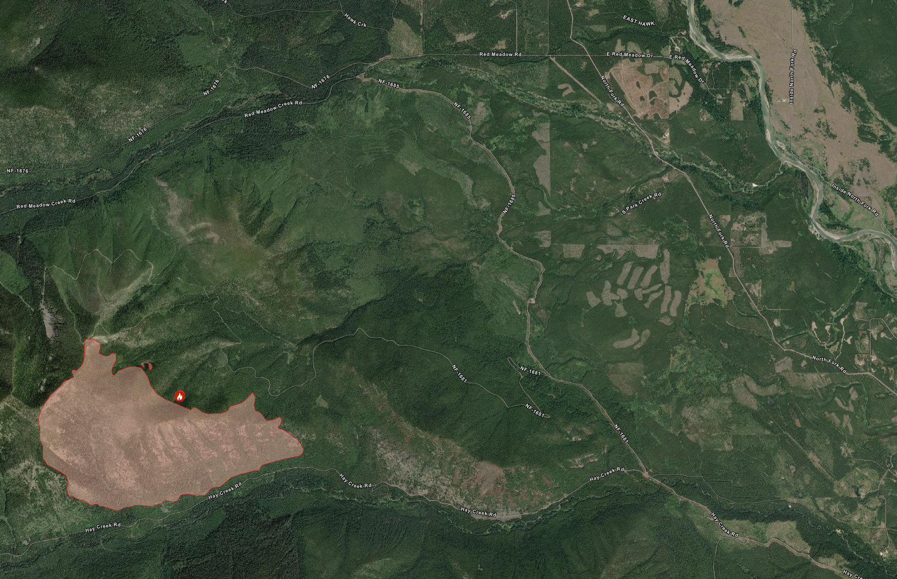
The Hay Creek Fire is now just under 1160 acres (470ha) and has reached, and even crossed, the Hay Creek Road at a few spots . . .
The Hay Creek Fire is now just under 1160 acres (470ha) and has reached, and even crossed, the Hay Creek Road at a few spots . . .
(PDF version of this document: 2021-07-24-HayCreek-FNF-Update FINAL.pdf)
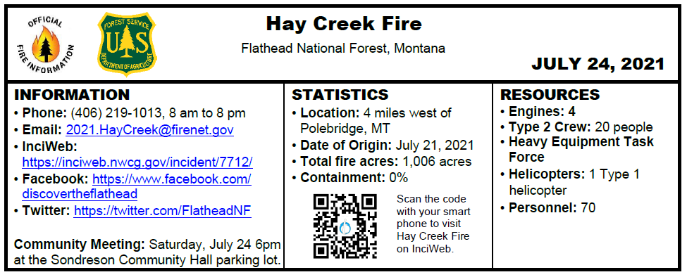
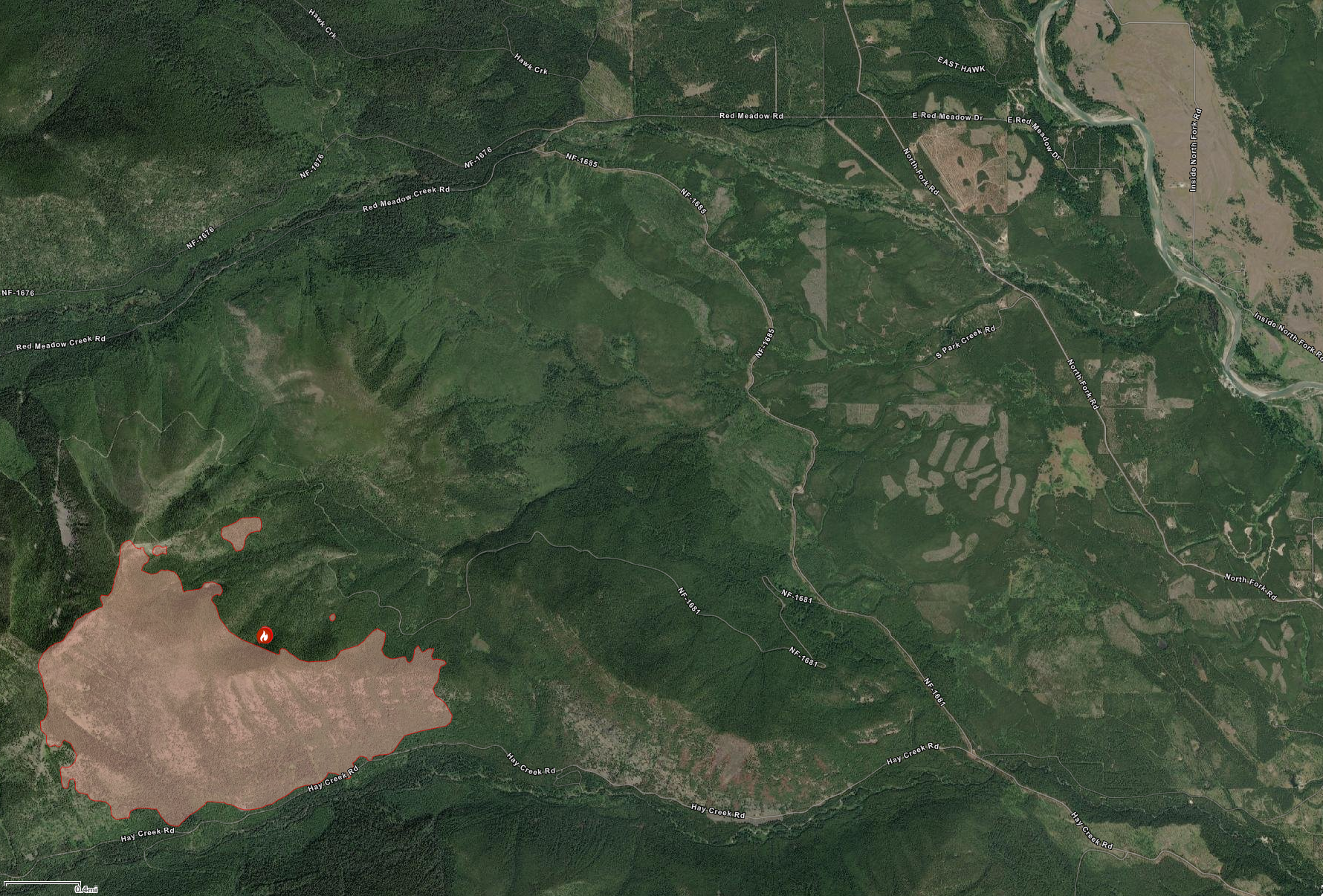
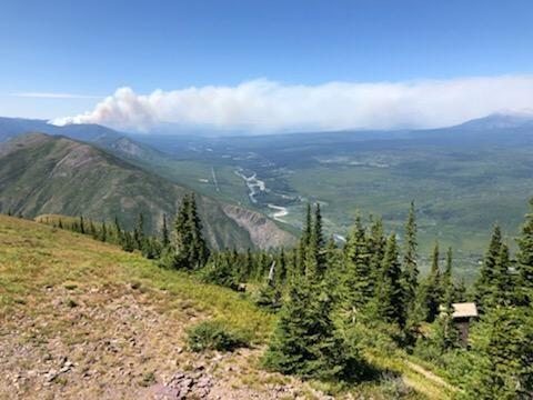
The Hay Creek fire grew to over 1,006 acres Friday afternoon and is currently 4 miles west of Polebridge. The fire is burning in heavy decadent timber on steep slopes of the Hay Creek and South Fork Red Meadow drainages. Single and group tree torching, short-range spotting, and short crown runs occurred throughout the afternoon. This moderate fire behavior combined with the heavy timber fuel type resulted in substantial smoke production. The fire is more active on drier south-facing slopes and under wind influence, but moderates on north-facing slopes. Today firefighting resources including heavy equipment and hand-crews will continue brushing out roads and improving fuel breaks on the Hay Creek, Red Meadow, and Spruce Creek Roads.
The Flathead County Sheriff’s department issued 20 pre-evacuation notices to structures in the vicinity of the Hay Creek Fire on Wednesday, July 22. See details at Inciweb: July 22, 2021 Evacuation Warning
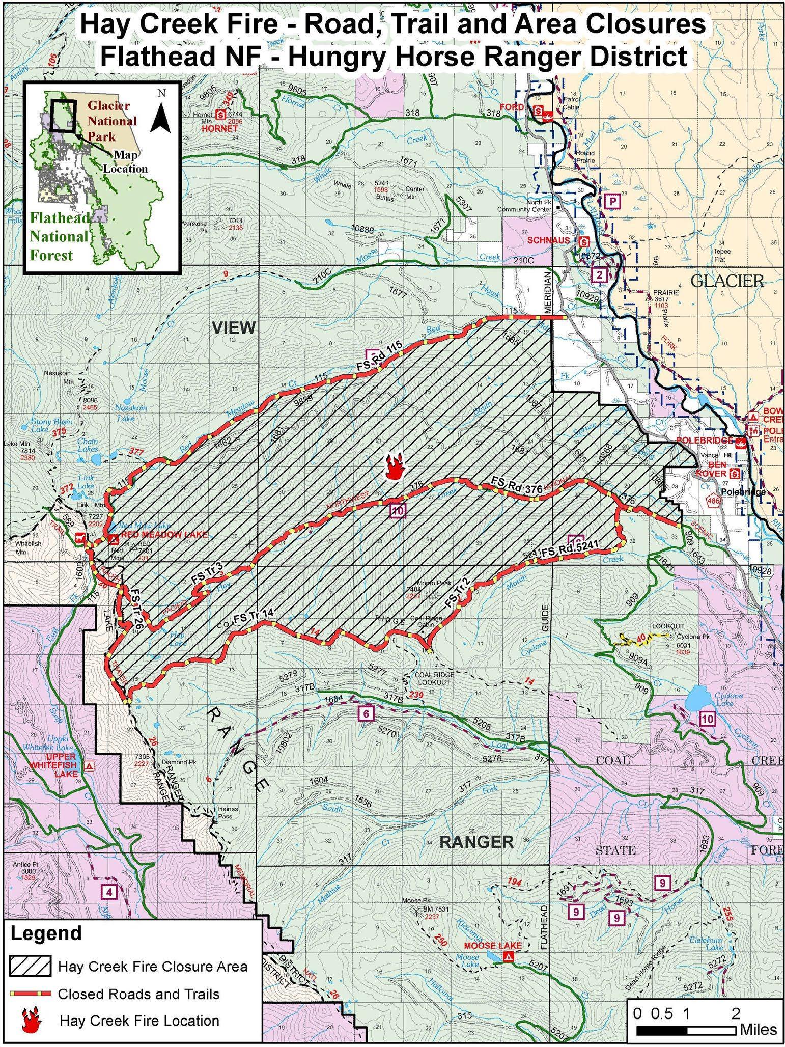
Road and trail closures are in place. See details at Inciweb: Flathead National Forest Closure Order
Continue reading Hay Creek Fire – Incident Update for July 24
As of this morning (July 24), the size of the Hay Creek Fire is estimated at about 1000 acres (405ha). This image from the Montana DNRC’s Interactive Wildland Fire Map website shows the fire boundary in context with the nearby area . . .
Please note that there is a community meeting Saturday, July 24th at 6:00PM. The meeting will take place at the Sondreson Community Hall parking lot.
Incident Update
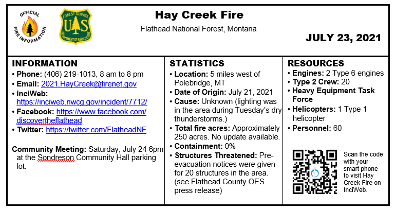
Resources on scene observed active fire behavior through the night. The fire is burning in the Hay Creek drainage in the North Fork of the Flathead National Forest and is being managed for full suppression. Due to safety concerns associated with steep terrain, thick timber, and current fuel conditions, fire managers are using indirect tactics. Today firefighters will continue brushing out roads and improving fuel breaks on the Hay Creek, Red Meadow, and Spruce Creek Roads, as assessing the need for future structure protection
Fire command transitioned to a Type 3 Incident Management Team 6am Friday morning, July 23, 2021.
EVACUATIONS / STRUCTURES THREATENED
The Flathead County Sheriff’s department issued 20 pre-evacuation notices to structure in vicinity of the Hay Creek Fire on Wednesday. See associated pre-evacuation notice.
Weather Continue reading Hay Creek Fire – Incident Update for July 23
From the Hay Creek Fire InciWeb site . . .
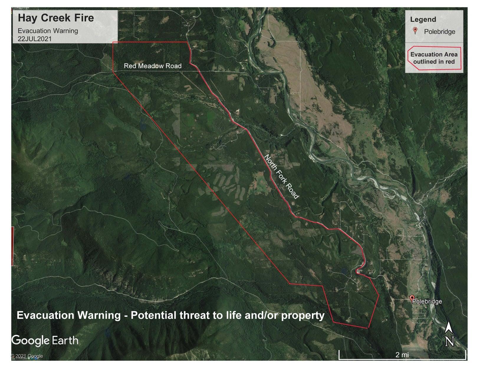
Flathead County Sheriff’s Office issued an Evacuation Warning to residences in the North Fork Area earlier today [July 22, 2021]. The Evacuation Warning area begins at approximately the Gravel Pit North of Polebridge, including residents accessing their home from Long Bow Trail, and follows the North Fork Road up to Red Meadow Road, then extends West. The Evacuation Warning also includes residents on the North side of Red Meadow Road. Please see the attached Hay Creek Fire Evacuation Warning Map dated 22JUL2021.
An Evacuation Warning means there is a potential threat to life and/or property. This warning is issued to give residents time to prepare for a possible evacuation. Residents & Visitors who require additional time to evacuate or need to move pets or livestock are advised to begin the evacuation process now.
All right! The Inciweb site for the Hay Creek Fire is on the air. It is still not fully populated, but already has some useful information, including the fact that a Type 3 management team takes over Friday morning.
From a Moose Creek resident…
Sheriff was just here. They are focusing Red Meadow to Hay Creek today just to say what is going on. They will reassess tomorrow and head up Whale and Moose Creek. They may close the NF to non landowners in 3 or 4 days. Of course short of helicopters and crew but lots of fire engines, grading NF road as well. He said spread the word.
Note that the fire danger in Flathead County is now rated at Extreme.
This press release is also downloadable in PDF format…
 Northern Rockies Coordination Group
Northwest Montana Area
For Immediate Release: July 22, 2021
Stage II Fire Restrictions Implemented across NW Montana
Kalispell, MT, July 22, 2021 — Interagency fire managers agreed to implement Stage II Fire Restrictions that will go into effect at 12:01am Monday, July 26th, 2021 across the Flathead National Forest, Glacier National Park, Montana Fish, Wildlife, and Parks sites, Montana Department of Natural Resources and Conservation Kalispell, Stillwater, and Swan Units, and Flathead County.
Continue reading Stage II Fire Restrictions Implemented across NW Montana
Here we go again. Note that the fire danger in Flathead County is rated at Very High. From the official press release . . .
Northern Rockies Coordination Group
Northwest Montana Area
For Immediate Release: July 15, 2021
Fire Restrictions Updated for NW Montana
Kalispell, MT, July 15, 2021 — Interagency fire managers agreed to implement Stage I Fire Restrictions that will go into effect at 12:01am Saturday, July 17th, 2021 across the Flathead National Forest, Glacier National Park, Montana Department of Natural Resources and Conservation Kalispell, Stillwater, and Swan Units, and Flathead County.
Interagency fire managers are implementing Stage II Fire Restrictions that will go into effect at 12:01am Saturday, July 17th, 2021 across the Kootenai National Forest, Montana Department of Natural Resources and Conservation Libby Unit, Sanders and Lake County lands.
Interagency fire managers are implementing Stage II Fire Restrictions that will go into effect at 12:00am Friday, July 16th, 2021 across Lincoln County lands.
Continue reading Fire restrictions updated for NW Montana; Flathead County at Stage I Saturday
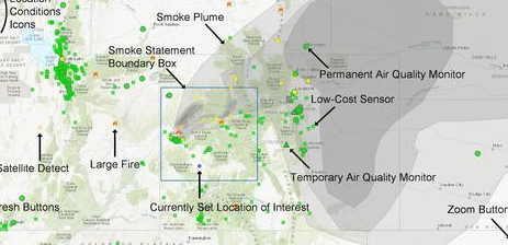 With fire season fast approaching, this is a nice find. This very handy map showing fires, air quality and smoke plumes is part of the U.S. EPA’s “AirNow” air quality website. Use this link for a map centered on Columbia Falls, MT: https://fire.airnow.gov/?lat=48.3637&lng=-114.1893&zoom=7#. Or you can find it on the NFPA’s “Wildfire Information” page.