From the official press release. Note: It appears from the attached map that this work runs on through the pass to include Grave Creek Road on the Kootenai National Forest side . . .
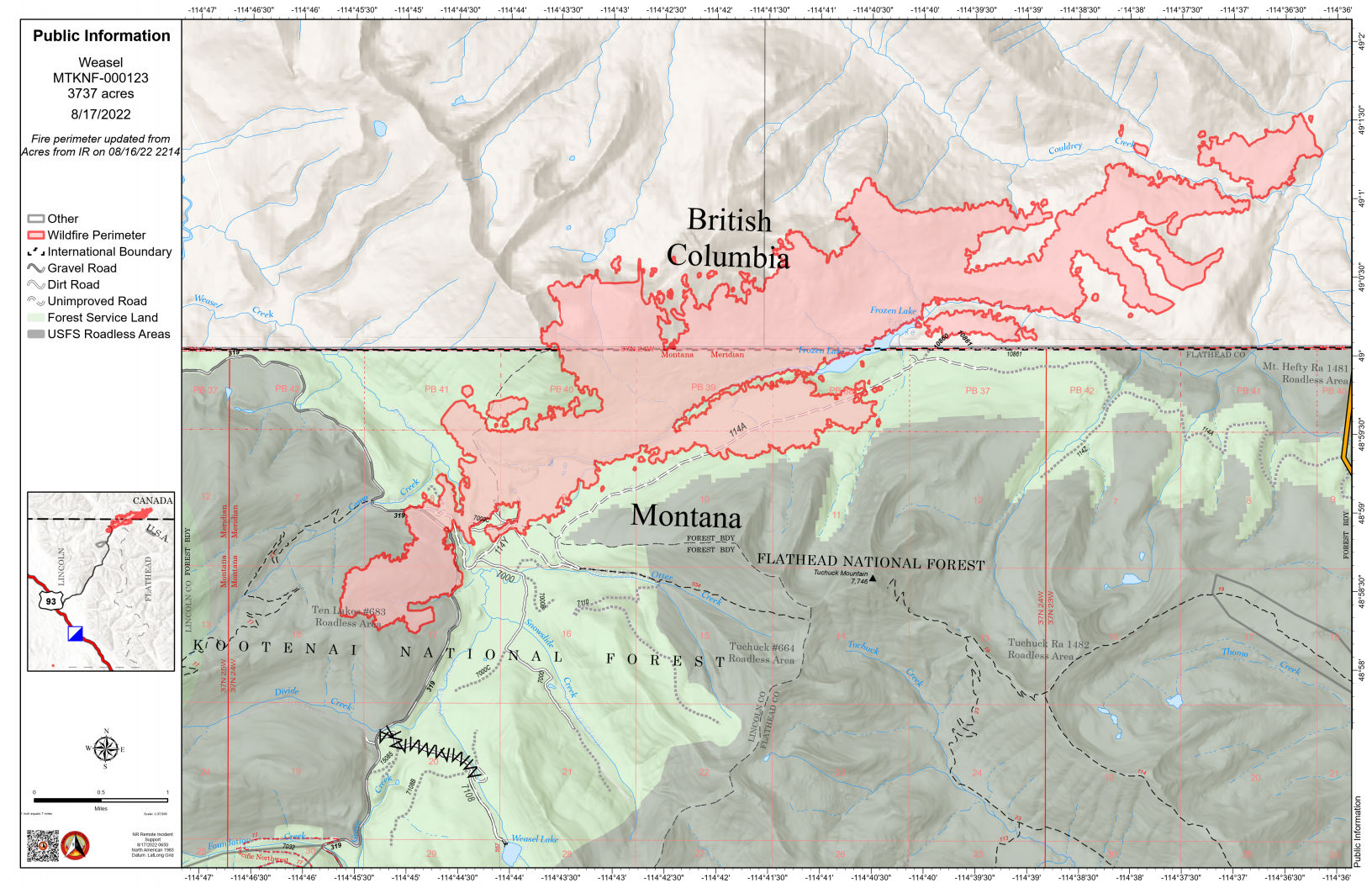
Kalispell, MT August 17, 2022 –National Forest System Road 114, Trail Creek Road, will be closed starting August 22 for heavy road maintenance. The work will begin three miles west of the Trail Creek and North Fork Road junction on the Flathead National Forest boundary. The project is anticipated to take up to four weeks to complete.
Summary: The weasel Fire added 78 acres yesterday, almost entirely within Canada. It is 20% contained…
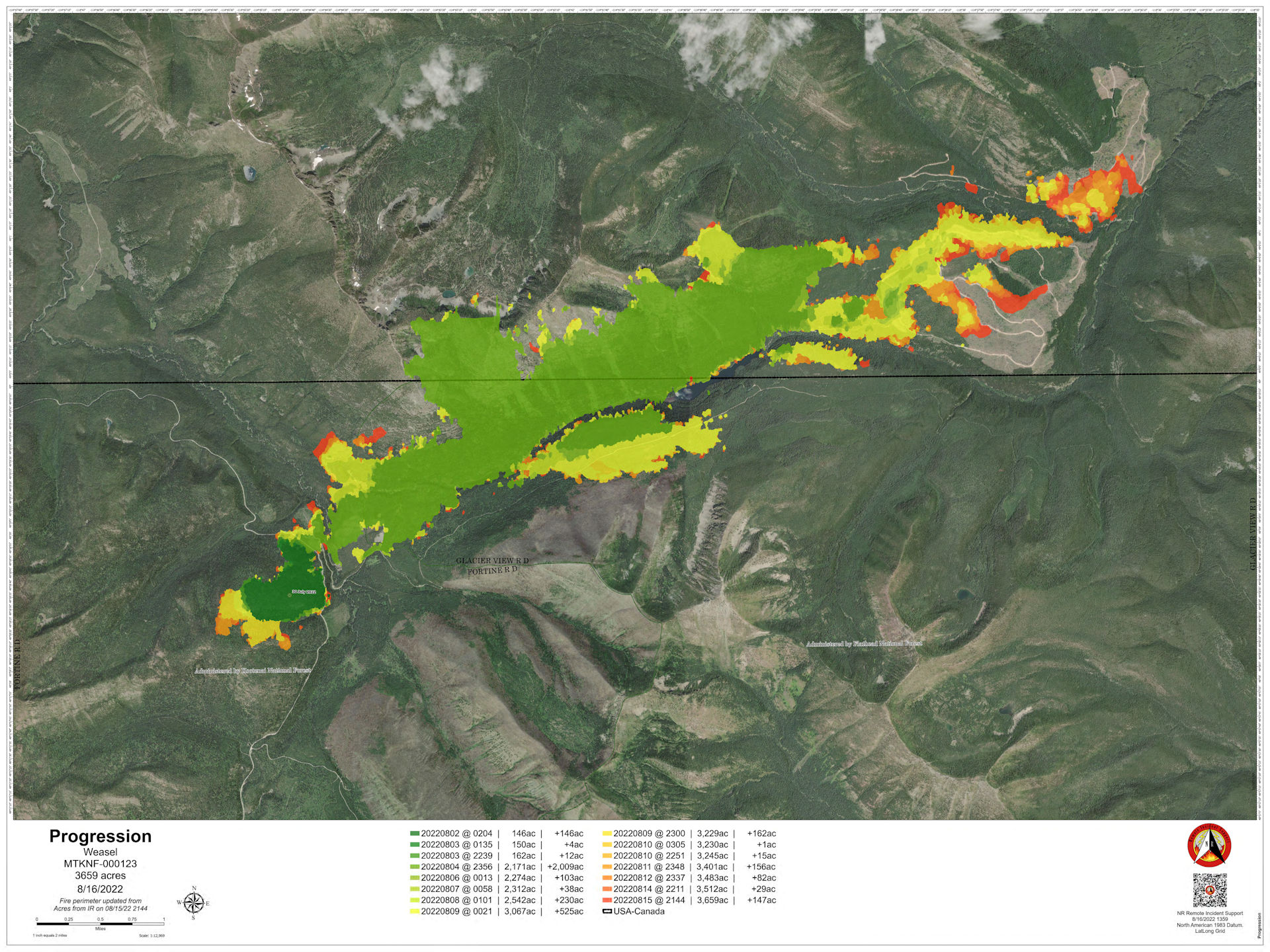
(Bonus! We have a fire progression map today, showing the fire’s daily spread up through yesterday. See below.)
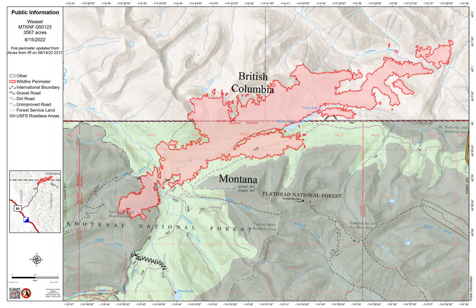
According to this morning’s IR (heat mapping) pass, the Weasel Fire gained 78 acres yesterday and is now estimated at 3737 acres. Better than half of this area (about 55%) is in Canada. The fire is now 20% contained. There’s still lots of heat within the fire’s boundaries, but most of its expansion was in Canada, along the northeastern and eastern flanks. The blaze is currently burning in the Kootenai National Forest, the far northwest corner of the North Fork in the Flathead Forest’s Glacier View district, and in Canada. See the attached map for fire location and extent.
The US and Canada are working together to control the Weasel Fire. From the InciWeb site: Jurisdictional collaboration is occurring between the Incident Management Team (IMT) in the United States located in Eureka, Montana and the BC Wildfire Service Incident Management Team in Canada, located in Cranbrook. The two IMT’s are closely coordinating on wildfire management and are sharing resources as required.
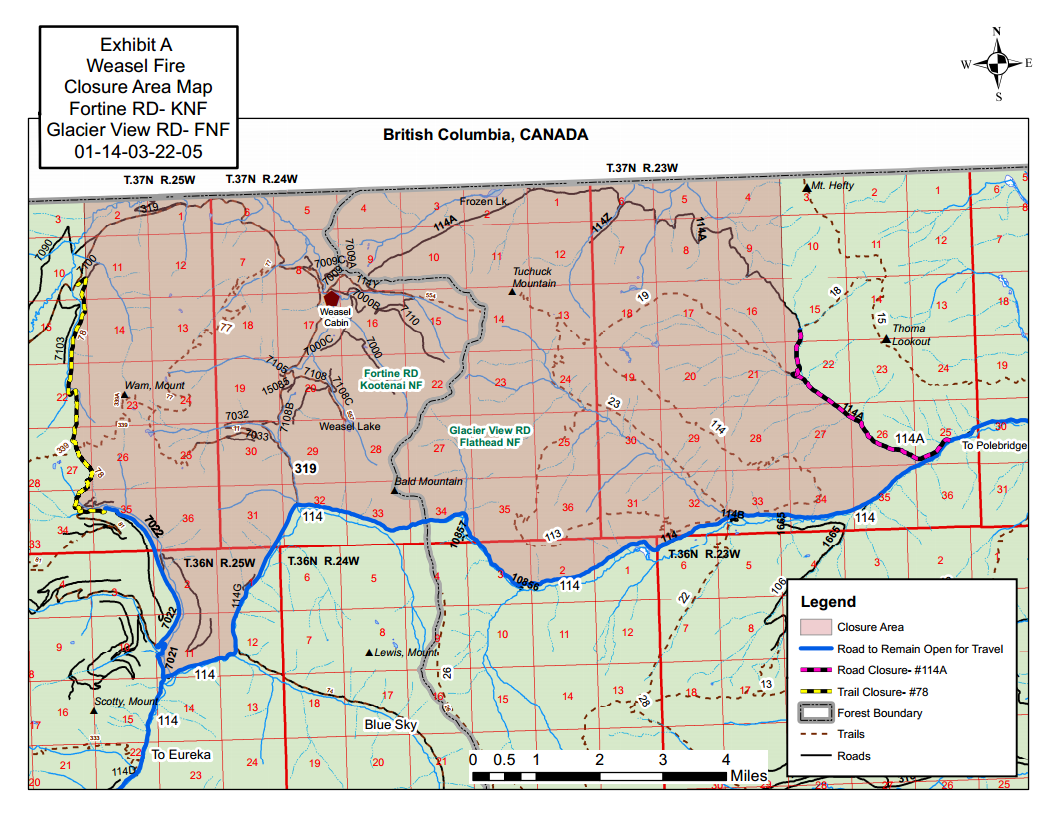
The area closure associated with the fire was finalized August 9 and includes segments of both the Kootenai and Flathead Forests. For the North Fork, this affects an area above Trail Creek Road north to the border and from the Whitefish Divide east to the Frozen Lake Road vicinity. Trail Creek Road remains open. See the attached map and closure order document. Also note that, beginning August 22, major work will be in progress in the Glacier View Ranger District on Trail Creek Road (NFS 114) that will restrict travel for about a month.
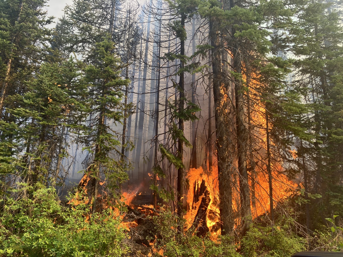
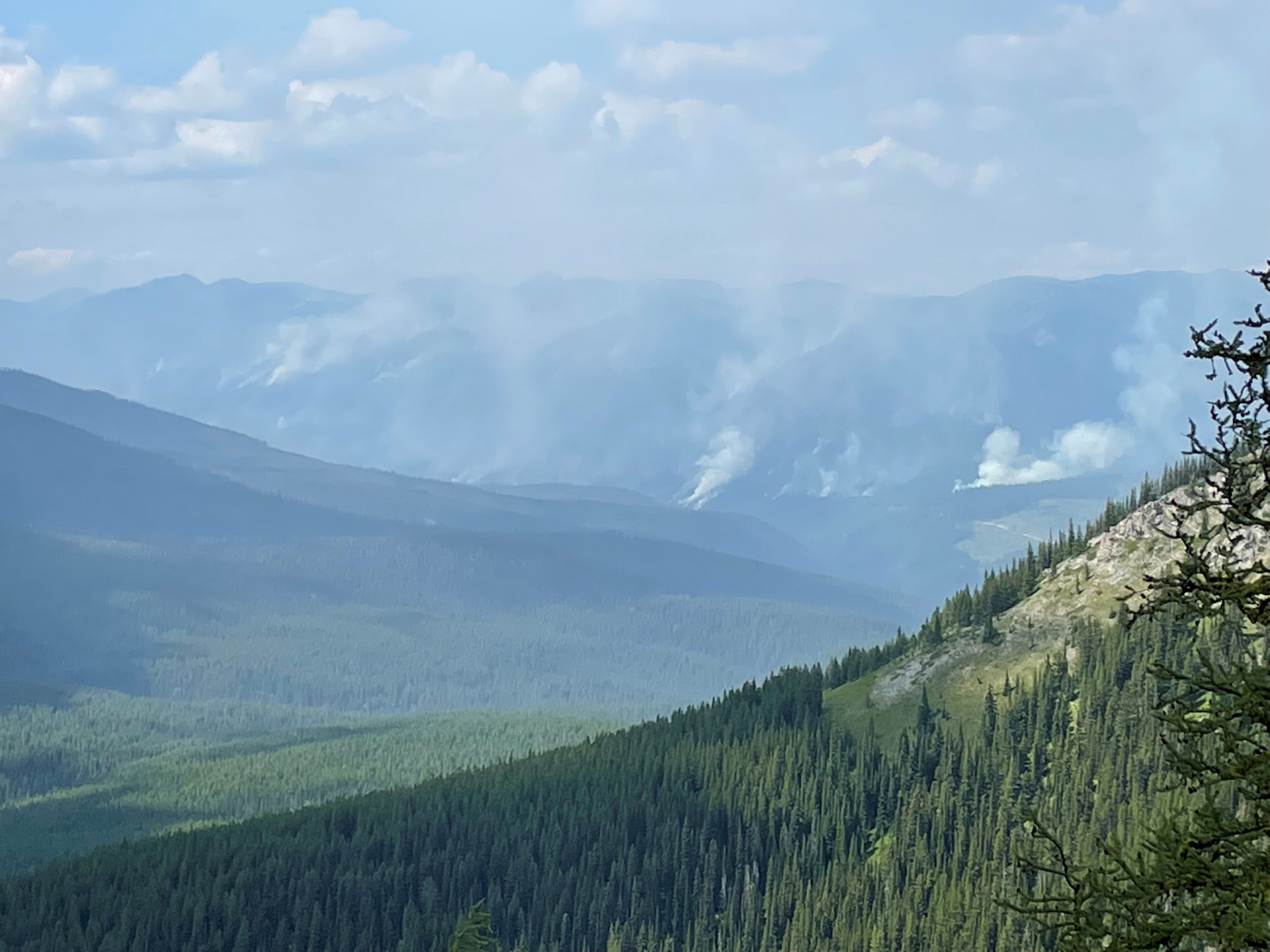
Weasel Fire on August 5, 2022, by Leif Haugen, Thoma Lookout
Summary: The weasel Fire continues to be active, adding 92 acres yesterday distributed along the western, southern and eastern flanks in the U.S. and Canada…
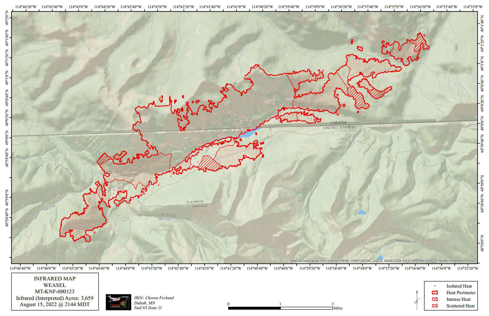
According to this morning’s IR (heat mapping) pass, the Weasel Fire gained 92 acres yesterday and is now estimated at 3659 acres. Better than half of this area (about 54%) is in Canada. The fire continues to be very active, with intense heat in the expansion zones as well as in several portions of the northeastern, southern, and southwestern flanks of the fire. There are also several hot spots scattered throughout the interior. The blaze is currently burning in the Kootenai National Forest, the far northwest corner of the North Fork in the Flathead Forest’s Glacier View district, and in Canada. See the attached map for fire location and extent.
The US and Canada are working together to control the Weasel Fire. From the InciWeb site: Jurisdictional collaboration is occurring between the Incident Management Team (IMT) in the United States located in Eureka, Montana and the BC Wildfire Service Incident Management Team in Canada, located in Cranbrook. The two IMT’s are closely coordinating on wildfire management and are sharing resources as required.
The area closure associated with the fire was finalized August 9 and includes segments of both the Kootenai and Flathead Forests. For the North Fork, this affects an area above Trail Creek Road north to the border and from the Whitefish Divide east to the Frozen Lake Road vicinity. Trail Creek Road remains open. See the attached map and closure order document. Also note that, beginning August 22, major work will be in progress in the Glacier View Ranger District on Trail Creek Road (NFS 114) that will restrict travel for about a month.
East flank of Weasel Creek fire, August 13, 2022 – BC Wildlife Service (Canada)
Summary: The weasel Fire added 55 acres yesterday, primarily along the western section in the U.S. and the eastern areas within Canada…
According to this morning’s IR (heat mapping) pass, the Weasel Fire gained 55 acres yesterday and is now estimated at 3567 acres. Better than half of this area (about 54%) is in Canada. Expansion was along the the west and northwest perimeters in the U.S. and to the northeast and east in Canada. The blaze is currently burning in the Kootenai National Forest, the far northwest corner of the North Fork in the Flathead Forest’s Glacier View district, and in Canada. See the attached map for fire location and extent.
The US and Canada are working together to control the Weasel Fire. From the InciWeb site: Jurisdictional collaboration is occurring between the Incident Management Team (IMT) in the United States located in Eureka, Montana and the BC Wildfire Service Incident Management Team in Canada, located in Cranbrook. The two IMT’s are closely coordinating on wildfire management and are sharing resources as required.
The area closure associated with the fire was finalized August 9 and includes segments of both the Kootenai and Flathead Forests. For the North Fork, this affects an area above Trail Creek Road north to the border and from the Whitefish Divide east to the Frozen Lake Road vicinity. Trail Creek Road remains open. See the attached map and closure order document. Also note that, beginning August 22, major work will be in progress in the Glacier View Ranger District on Trail Creek Road (NFS 114) that will restrict travel for about a month.
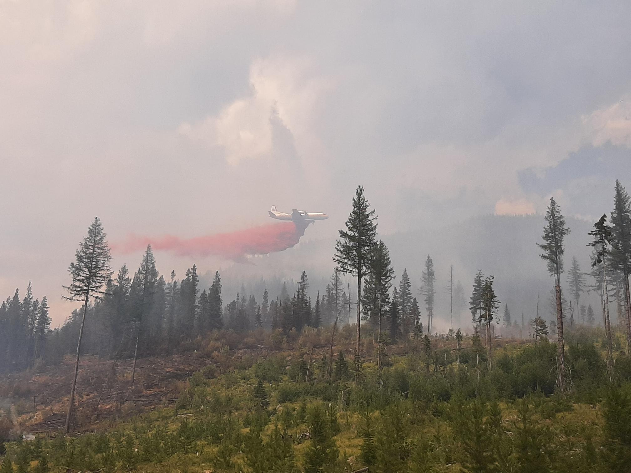
An airtanker making a run on the Weasel Creek wildfire, August 12, 2022 – BC Wildlife Service (Canada)
Summary: The weasel Fire added only 29 acres yesterday, almost entirely within Canada…
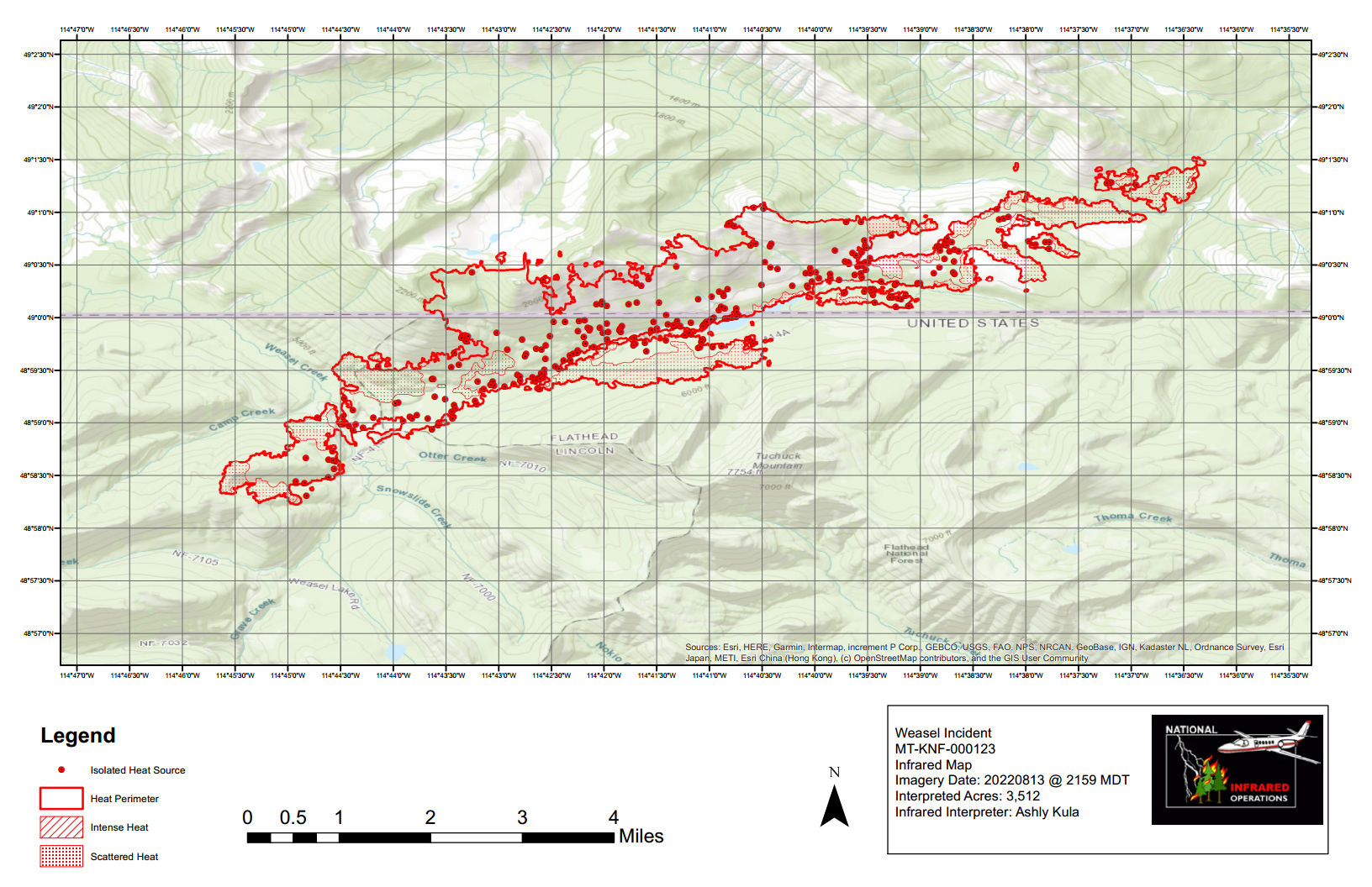
According to this morning’s IR (heat mapping) pass, the Weasel Fire gained 29 acres yesterday and is now estimated at 3512 acres. Better than half of this area and most of the currently active fire zone is in Canada. Expansion was along the the northeast and east perimeters in Canada. The blaze is currently burning in the Kootenai National Forest, the far northwest corner of the North Fork in the Flathead Forest’s Glacier View district, and in Canada. See the attached map for fire location and extent.
The US and Canada are working together to control the Weasel Fire. From the InciWeb site: Jurisdictional collaboration is occurring between the Incident Management Team (IMT) in the United States located in Eureka, Montana and the BC Wildfire Service Incident Management Team in Canada, located in Cranbrook. The two IMT’s are closely coordinating on wildfire management and are sharing resources as required.
The area closure associated with the fire was finalized August 9 and includes segments of both the Kootenai and Flathead Forests. For the North Fork, this affects an area above Trail Creek Road north to the border and from the Whitefish Divide east to the Frozen Lake Road vicinity. Trail Creek Road remains open. See the attached map and closure order document. Also note that, beginning August 22, major work will be in progress in the Glacier View Ranger District on Trail Creek Road (NFS 114) that will restrict travel for about a month.
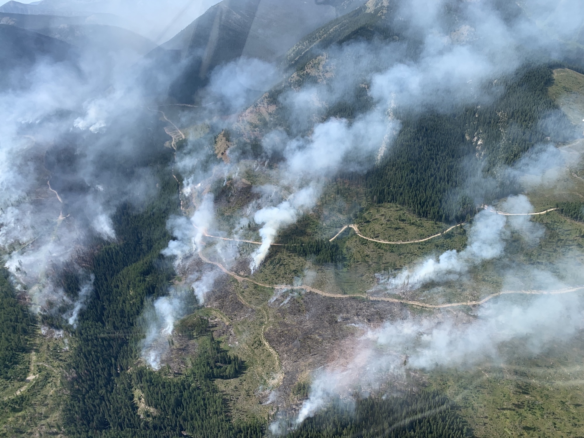
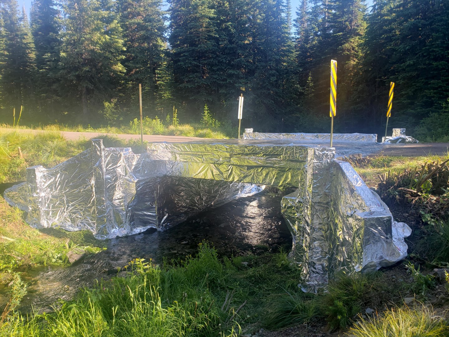
Weasel Fire – Wrapped Bridge, August 5, 2022 – USFS
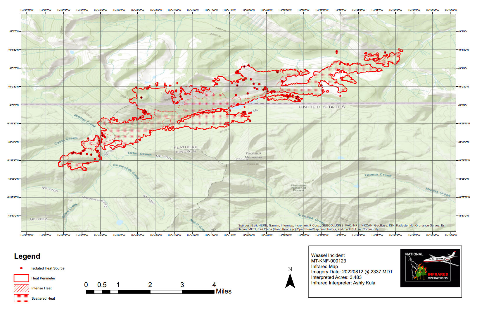
Summary: The weasel Fire added 82 acres yesterday, distributed here and there along the western and southern edges, and to the northeast and east in Canada…
According to this morning’s IR (heat mapping) pass, the Weasel Fire gained 82 acres yesterday and is now estimated at 3483 acres. Better than half of this area is in Canada. Expansion was distributed here and there along the western and southern areas in the U.S., and to the northeast and east in Canada. The blaze is currently burning in the Kootenai National Forest, the far northwest corner of the North Fork in the Flathead Forest’s Glacier View district, and in Canada. See the attached map for fire location and extent.
The US and Canada are working together to control the Weasel Fire. From the InciWeb site: Jurisdictional collaboration is occurring between the Incident Management Team (IMT) in the United States located in Eureka, Montana and the BC Wildfire Service Incident Management Team in Canada, located in Cranbrook. The two IMT’s are closely coordinating on wildfire management and are sharing resources as required.
The area closure associated with the fire was finalized August 9 and includes segments of both the Kootenai and Flathead Forests. For the North Fork, this affects an area above Trail Creek Road north to the border and from the Whitefish Divide east to the Frozen Lake Road vicinity. Trail Creek Road remains open. See the attached map and closure order document. Also note that, beginning August 22, major work will be in progress in the Glacier View Ranger District on Trail Creek Road (NFS 114) that will restrict travel for about a month.
NFLA Elections & General Meeting Sondreson Hall Speaker at 7pm Meeting & Elections at 8pm
The regular NFLA meeting starts at 8:00pm. This is an important one as it includes a couple of big events: the election of officers and board members and the approval of several proposed adjustments to the NFLA bylaws.
This month’s presentation kicks off at 7:00pm with a talk by Debo Powers and Suzanne Hildner on the “Polebridge Bear Smart Program.” (We don’t know if they will be wearing their bear costumes. One can only hope.)
Summary: The weasel Fire added 156 acres yesterday, mostly along the western edge and to the northeast and east in Canada…
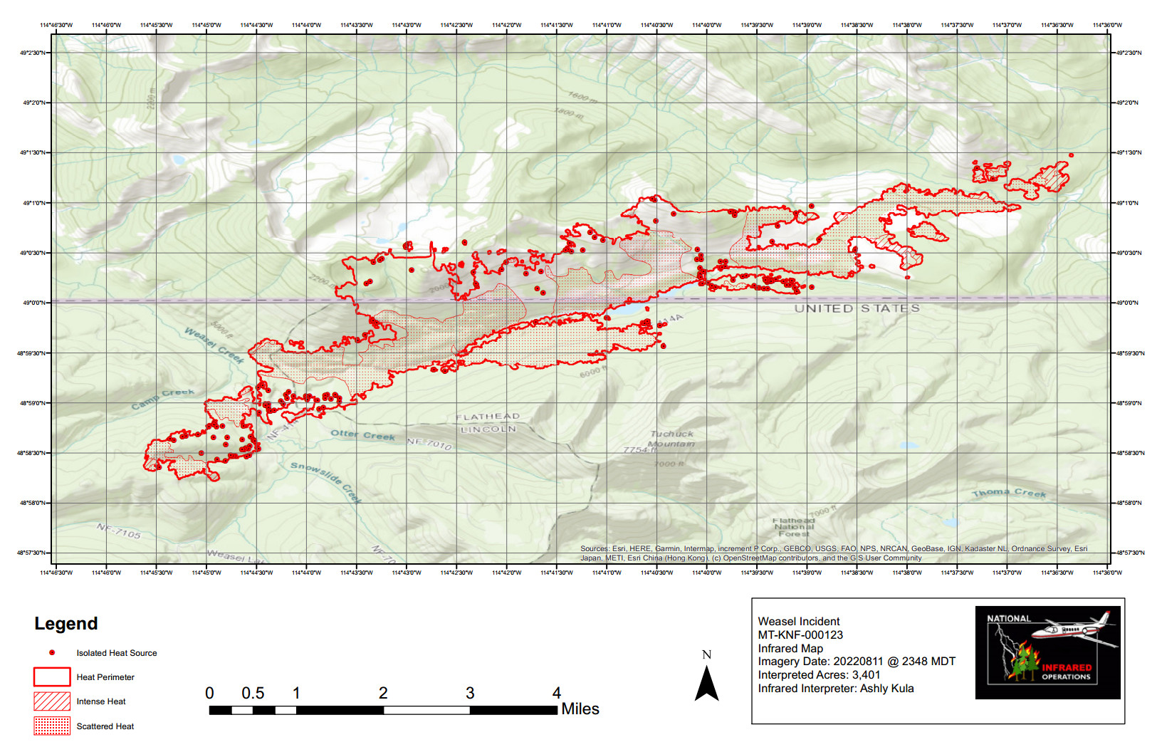
According to this morning’s IR (heat mapping) pass, the Weasel Fire gained 156 acres yesterday and is now estimated at 3401 acres, with a little over half its area in Canada. Expansion was distributed mostly along the western edge in Lincoln County and, in Canada, along the northeast and to the leading edges of the “island perimeters” east of the main burn. The blaze is currently burning in the Kootenai National Forest, the far northwest corner of the North Fork in the Flathead Forest’s Glacier View district, and in Canada. See the attached map for fire location and extent.
The US and Canada are working together to control the Weasel Fire. From the InciWeb site: Jurisdictional collaboration is occurring between the Incident Management Team (IMT) in the United States located in Eureka, Montana and the BC Wildfire Service Incident Management Team in Canada, located in Cranbrook. The two IMT’s are closely coordinating on wildfire management and are sharing resources as required.
The area closure associated with the fire was finalized August 9 and includes segments of both the Kootenai and Flathead Forests. For the North Fork, this affects an area above Trail Creek Road north to the border and from the Whitefish Divide east to the Frozen Lake Road vicinity. Trail Creek Road remains open. See the attached map and closure order document. Also note that, beginning August 22, major work will be in progress in the Glacier View Ranger District on Trail Creek Road (NFS 114) that will restrict travel for about a month.
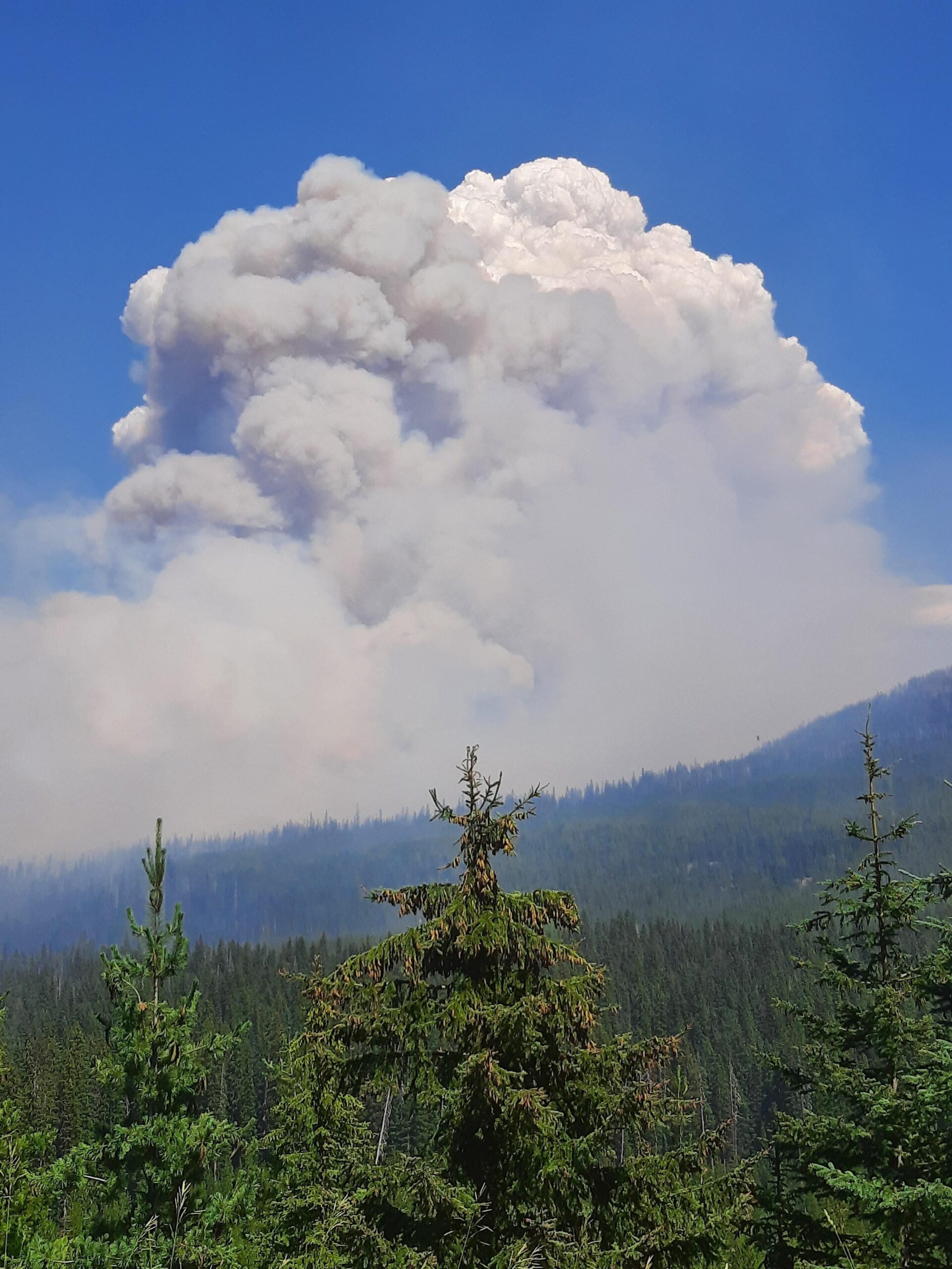
Weasel Creek Wildfire – Aggressive fire behaviour witnessed at 1600 August 8 – BC Wildlife Service (Canada)
Summary: The weasel Fire added only 16 acres yesterday, with minor advances in the same areas that have been active the past few days…
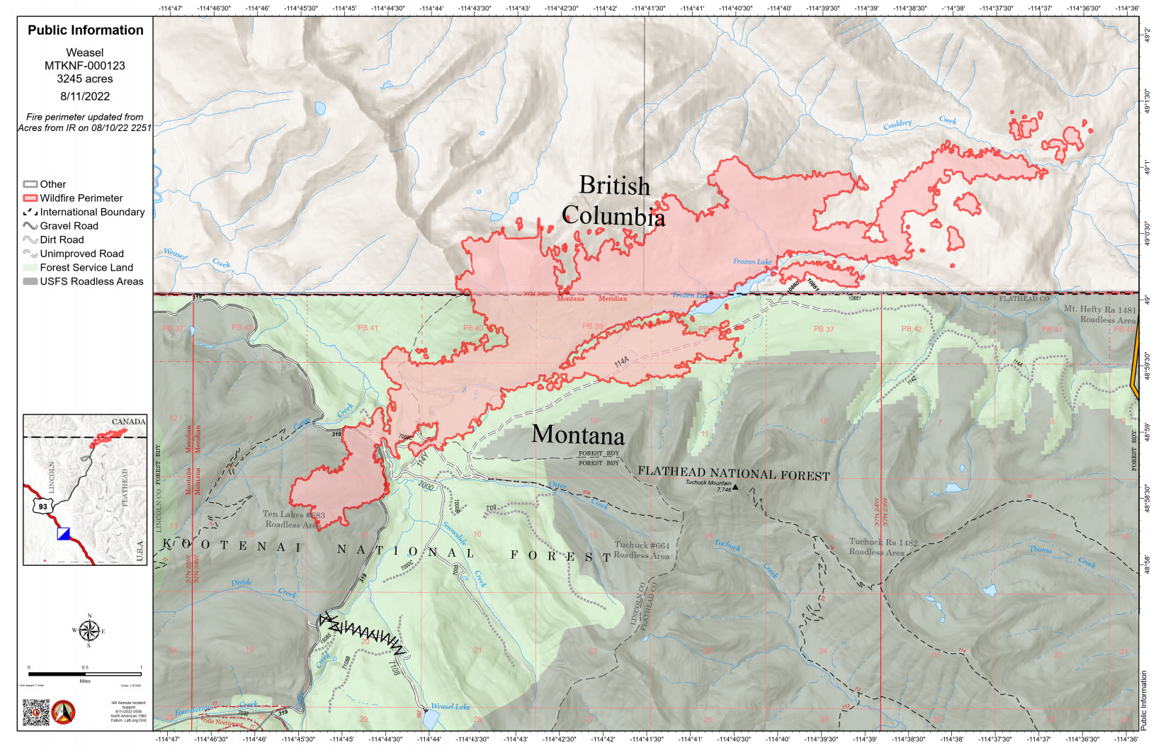
According to this morning’s IR (heat mapping) pass, the Weasel Fire gained 16 acres yesterday and is now estimated at 3245 acres, with a little over half its area in Canada. Expansion was distributed across the areas that have been active over the past few days: the Kootenai National Forest to the west, along the eastern/northeastern perimeter in Canada and in a section of the southern perimeter in the neighborhood of Frozen Lake where it is approaching the old 2017 Weasel burn scar. The blaze is currently burning in the Kootenai National Forest, the far northwest corner of the North Fork in the Flathead Forest’s Glacier View district, and in Canada. See the attached map for fire location and extent.
The US and Canada are working together to control the Weasel Fire. From the InciWeb site: Jurisdictional collaboration is occurring between the Incident Management Team (IMT) in the United States located in Eureka, Montana and the BC Wildfire Service Incident Management Team in Canada, located in Cranbrook. The two IMT’s are closely coordinating on wildfire management and are sharing resources as required.
The area closure associated with the fire was finalized August 9 and includes segments of both the Kootenai and Flathead Forests. For the North Fork, this affects an area above Trail Creek Road north to the border and from the Whitefish Divide east to the Frozen Lake Road vicinity. Trail Creek Road remains open. See the attached map and closure order document. Also note that, beginning August 22, major work will be in progress in the Glacier View Ranger District on Trail Creek Road (NFS 114) that will restrict travel for about a month.
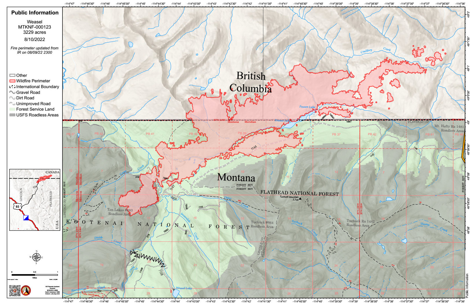
Summary: The weasel Fire added 162 acres yesterday, mostly to the west, south and east…
According to this morning’s IR (heat mapping) pass, the Weasel Fire gained 162 acres yesterday and is now estimated at 3229 acres. Most of the expansion was in the Kootenai National Forest to the west, along the eastern perimeter in Canada and in a section of the southern perimeter in the neighborhood of Frozen Lake where it is approaching the old 2017 Weasel burn scar. The blaze is currently burning in the Kootenai National Forest, the far northwest corner of the North Fork in the Flathead Forest’s Glacier View district, and in Canada. See the attached map for fire location and extent.
The US and Canada are working together to control the Weasel Fire. From the InciWeb site: Jurisdictional collaboration is occurring between the Incident Management Team (IMT) in the United States located in Eureka, Montana and the BC Wildfire Service Incident Management Team in Canada, located in Cranbrook. The two IMT’s are closely coordinating on wildfire management and are sharing resources as required.
The area closure associated with the fire was finalized August 9 and includes segments of both the Kootenai and Flathead Forests. For the North Fork, this affects an area above Trail Creek Road north to the border and from the Whitefish Divide east to the Frozen Lake Road vicinity. Trail Creek Road remains open. See the attached map and closure order document.
 Kalispell, MT August 17, 2022 –National Forest System Road 114, Trail Creek Road, will be closed starting August 22 for heavy road maintenance. The work will begin three miles west of the Trail Creek and North Fork Road junction on the Flathead National Forest boundary. The project is anticipated to take up to four weeks to complete.
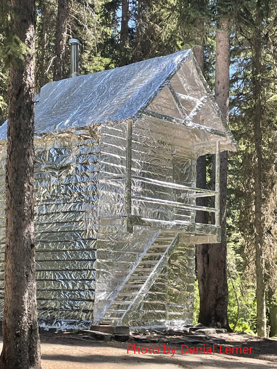
 The regular NFLA meeting starts at 8:00pm. This is an important one as it includes a couple of big events: the