August 1st National Wildfire Outlook Potential

The August 1st National Wildfire Outlook Potential is very consistent with what has been forecasted before and what we are seeing up the North Fork.  Bottom line for us is that we will see an above average August and September in terms of fire activity.  No real relief during that period, however the forecast is confident that the season will close out in late September/early October, which is a relief.

Significant-Wildland-Fire-Potential-Outlook-August-2018

Significant-Wildland-Fire-Potential-Outlook-September-2018We received  just a little bump of moisture a week ago – but all that did was extend the live fuel moistures for a week or so.  We’ll be curing out fast without additional precip, and at some point the minor amounts (less than a quarter of an inch) will not do much at all.  I was on the Kootenai Forest this week, and we need to feel fortunate in the North Fork that we have relatively moist fuels.  They don’t, and the number of fires they are staffing reflects that.

Stay watchful – water what you can, keep your grass mowed and trimmed, and watch for smoke.

Here is the link to the August 1st National Wildfire Outlook Potential:  https://www.nifc.gov/nicc/predictive/outlooks/monthly_seasonal_outlook.pdf.

July Wildland Fire Outlook

Wildfire-Map-July-2018

The July/August/September Outlook is posted. The bottom line is that it could be worse. They are forecasting a above normal July for North Idaho and the Kootenai west of us. I know our precip the last two weeks has made a difference, but it won’t last if we get another flash drought.

All in all, the forecast has seemed to moderate from the June forecast. Still, August and September will be Above Normal for us – and will last until late in September or early October. The monsoonal moisture is forecasted to push up into Southwestern Montana, which still means we may get dry lightning out on the edge of those air masses.

To get a copy of the report, tap here https://www.nifc.gov/nicc/predictive/outlooks/monthly_seasonal_outlook.pdf

June 2018 National Wildland Fire Outlook

There is essentially no change from the May Outlook for Northwest Montana.  I do see some indication that we might not have an extended season into October which would be good.  On the other hand, the monsoonal moisture that will be pushing up into the Yellowstone country could very well increase our dry lightning levels without bringing the moisture.  That could seriously affect us given hot and dry conditions.

We’ll look forward to the July issuance, but count on a very hot and dry July and August into September with a higher than normal wildfire activity level.  Get gutters cleaned out, lawns irrigated and mowed, and cleanup completed.

Here is the link to the June National Wildland Fire Outlook:  https://www.nifc.gov/nicc/predictive/outlooks/monthly_seasonal_outlook.pdf

Fire Season Outlook May-June-July

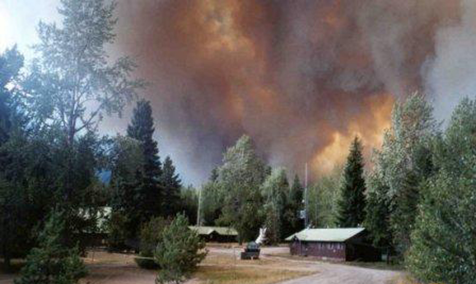
Well, I had hoped that we would get a better forecast for the fire season.  This doesn’t look good.

2018 Fire Outlook - June

2018 Fire Outlook - July

2018 Fire Outlook - August

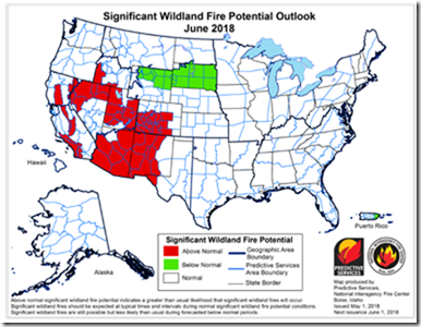
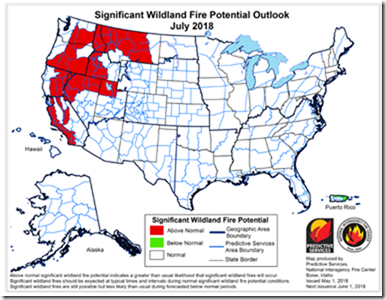
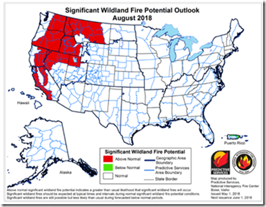
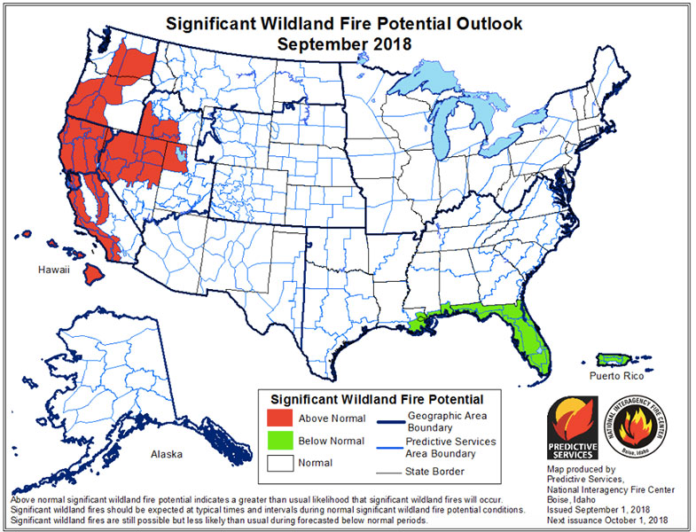
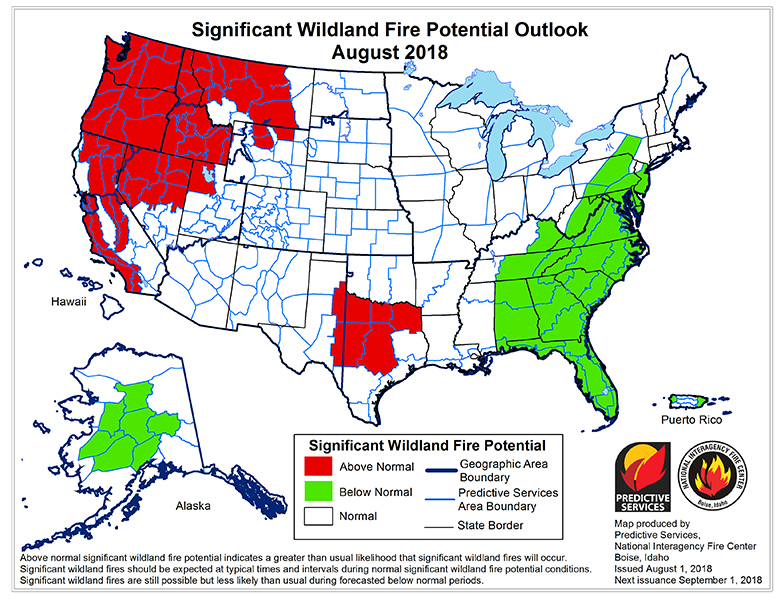
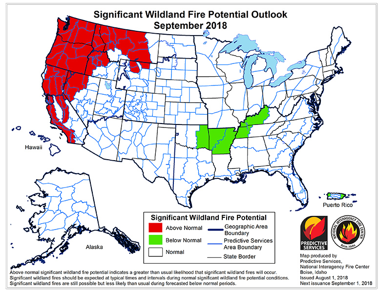
Northern Rockies: Normal Significant Wildland Fire Potential is expected for the Northern Rockies in May and June. For July and August, Above Normal Significant Wildland Fire Potential is expected from central Montana west through the Idaho Panhandle, excluding the Beaverhead Deer Lodge National forest. In this and other, eastern locations Normal Significant Wildland Fire Potential is expected.

With near average temperatures and precipitation expected in May and June, Normal Significant Wildland Fire Potential is anticipated across the region as fuels will still be transitioning to drier levels, especially at higher elevations west of the Continental Divide. In early July, higher elevations may still be relatively moist due to the enhanced snowpack in the western areas. By the last half of July, however, heavy cured fine fuel loading and drier larger fuels are expected to elevate potential to “above-normal” in the Idaho and western/central Montana areas since the temperature and precipitation outlooks favor warmer and drier conditions. Above Normal potential with warmer and drier than average conditions will continue in August in those locations depicted on the maps. Southwestern Montana, Yellowstone National Park, and the Absaroka-Beartooth mountains/plateau, southwest Montana will remain near normal based on anticipated monsoonal moisture bringing adequate precipitation to these areas through the entire outlook period.

While the forecast for lightning is not included in this Outlook, the reference to monsoonal moisture moving into SW Montana implies that those air masses will be present in the Northern Rockies.  Even if the air masses dry out before hitting Northwest Montana, the residual moisture can lead to significant convection and lightning.  We can be hot and dry, but if we don’t get starts we can be OK.  If we get a lot of dry lightning under hot dry conditions, it will be very challenging.

We haven’t had back to back extreme fire seasons in the Northern Rockies in my experience.  However, we might be turning a corner on that this year.  Keep your fingers crossed and get your fuels work done and be squared away for initial attack.  Could be a bad one.

Download the full report from here. https://www.nifc.gov/nicc/predictive/outlooks/monthly_seasonal_outlook.pdf

Wildfire Risk Assessment Request

2017 was a record year for Wildland Fire in Montana with some 1.4 million acres burned. Fortunately, the North Fork escaped large fires. However, with our long history of large fires in 1988, 2001 and 2003, it is only a matter of time before we see large fire return to the North Fork. Many North Fork residents have taken advantage of the free Wildland Fire Risk Assessments provided by both the Flathead Economic Policy Center (FEPC) and Montana Department of Natural Resources and Conservation. If you are interested in a free Assessment, fill out the attached form and return it to the FEPC. Grant money is available to assist landowners with hazardous fuels projects if they are interested.

2018 Winter Interlocal Information

Tim Manley giving the report for the FWP at the Winter Interlocal
Tim Manley giving the report for the FWP at the 2015 Winter Interlocal

Here’s a message from Rob Davies, District Ranger for the Flathead National Forest who is hosting this year’s winter interlocal.

The meeting will be held at the Glacier National Park, Community building, (the usual winter spot) in West Glacier, instead of the Hungry Horse Forest Service Conference room.

Date: Wed Feb 21
Place: Community Building, Glacier Ntl Park, West Glacier, MT
Time: 10:00 am to 1:00 pm

Tap here to get the agenda.

Tap here to get a draft of the questions that will be covered.

I’ll bring some snacks, coffee and tea. If you wish to bring additional snacks, treats, and potluck items, ……. That would be greatly appreciated.

See you there.

Rob

Forest Service Shield

Rob Davies, District Ranger, Forest Service
Flathead National Forest, Hungry Horse – Glacier View Ranger Districts
p: 406-387-3801 c: 406-640-0921 f: 406-387-3889
rdavies@fs.fed.us
PO Box 190340
Hungry Horse, MT, MT 59919
http://www.fs.fed.us
USDA Logo Forest Service Twitter USDA Facebook
Caring for the land and serving people

February 1, 2018 National Wildland Fire Potential Outlook

February 2018 National Significant Wildland Fire Potential Outlook

We are in good shape being out of season with reasonable moisture – snowpack is around 123% of normal for the Flathead.  I was just in Albuquerque last week, and they are in continued drought with their ski area unable to open because they have more bare ground than they do snow cover.  Grim.  Jackson Wyoming just cancelled a Skijoring event due to lack of snow as well.

I’ll keep you posted as things change going into the spring and continue into the fire season.  Fire season will be what it is, of course, but it is interesting to me to see how other parts of the country are being set up for active fire season.  That obviously affects availability of resources nationally when we do get active.
Be thankful we have as much snow as we  do.  It can’t hurt.

Here is the link to the February 1 National Wildland Fire Potential Outlook that covers February, March and April:

https://www.nifc.gov/nicc/predictive/outlooks/monthly_seasonal_outlook.pdf

Thanks!  Allen

September Wildland Fire Outlook

Here is the link to the September/October/November Wildland Fire Outlook: https://www.nifc.gov/nicc/predictive/outlooks/monthly_seasonal_outlook.pdf

For September in the Northern Rockies: Above Normal significant large fire potential is expected in all areas except Yellowstone National Park and eastern North Dakota in September where Normal Potential is expected.

In October Above Normal significant large fire potential will continue across the southern Idaho Panhandle and across most of Montana, except the Kootenai Region and Southwest Montana. Western North Dakota will also experience elevated potential in October as well.

This is grim news. While we will see diminished potential for lightning starts as the season progresses, the relief we need in terms of a season-ending moisture event looks elusive. And with the number of new starts across the state during the past few days, there is a lot of fire on the landscape that will not go out on its own. In addition we don’t have enough overhead teams/crews/engines/aircraft to staff the fires that are active now.

This is going to be a very tough September and October for Montana. I’m hoping that escaped hunter fires don’t add significantly to the fire situation….

Let’s be careful out there.

Outlook for Wildland Fire for August/September/October

Significant Wildland Fire Potential Outlook for August 2017

Here is the Outlook for Wildland Fire for August/September/October:  https://www.nifc.gov/nicc/predictive/outlooks/monthly_seasonal_outlook.pdf

This Outlook better represents the conditions we are seeing, both up the North Fork as well in more severe burning conditions across the rest of Montana.  This is in sharp contrast to the forecast from Predictive Services we received at our IMT Spring Meetings which forecasted a “slow normal” fire season for the Northern Rockies.  I think we have exceeded the acres burned by August 1 that they forecasted for the entire season – and you all know that we have six to eight weeks of fire season left.

I just returned yesterday from a 12 day assignment as Deputy Plans Chief with Shawn Pearson’s North Idaho Type 2 Team on the Sunrise Fire outside of Superior, Montana.  Doug Turman’s Type 1 Team replaced us, because it is truly a Type 1 Fire.  Pearson’s Team had been assigned several days before I was ordered – I was one of the folks they ordered to expand the Team’s capability to manage a complex incident.

The fuels in Southwest Montana are extremely dry.  Operations did an incredible job burning out heavy fuels around structures that had been evacuated.  As I left yesterday, the Team had not lost a structure, which was incredible as well.  Our fuels in the mid and higher elevations in the Flathead are retaining more live fuel moisture, but that may not last long if the heat does not moderate.  This is very similar to the 2007 fire season where the Flathead saw large fires – Brush Creek west of Whitefish in Star Meadows, and Skyland Creek Fire in the Skyland Creek area that burned over Marias Pass through the Lewis and Clark National Forest, and onto the Blackfeet Reservation.  The North Fork dodged the bullet in 2007.  I hope we are as fortunate again.

Anyway, I’m thinking I may not have much time up the North Fork until after the season ends.  And I wouldn’t expect that until October 1 at the earliest.  We all know they can extend with nice fall weather as well.